![]()
United
Nations
Tempête sévère

Definition
Facts and figures
Further information
UN-SPIDER Regional Support Offices with hazard-specific expertise
Related content on the Knowledge Portal
 Publishing institution:
, EMSN024, EMSN056)")
To meet the global challenges, the United Nations adopted several framework agreements, including the Sendai Framework for Disaster Risk Reduction at the Third United Nations World Conference on Disaster Risk Reduction (2015-2030). The framework builds the international reference point for disaster preparedness and focuses on reducing existing and future disaster risks as well as enhancing disaster resilience. In the Sendai framework, seven global targets have been agreed to measure global progress in implementing the framework through quantifiable indicators and to present, compare and evaluate the status and progress uniformly worldwide. The recording of the status and degree of target achievement using the agreed indicators requires the use of various data sources, which must be consistent and comparable in time and space in order to ensure global monitoring.
Publishing institution:
Millions of people in Mozambique, Malawi and Zimbabwe are struggling to cope with the aftermath of Cyclone Idai, which has swept through this part of southeast Africa over the last weeks, leaving devastation in its wake. It is thought that more than two million people in the three countries have been affected, but the extent of destruction is still unfolding.
The authorities and military are working to rescue people, but roads and other transport and communication links are cut off. In order to plan and execute this kind of emergency response it is vital to understand exactly which areas have been affected, especially as accessing people cut off is extremely challenging.
The disaster triggered activations of both the Copernicus Emergency Mapping Service and the…
read more04/04/2019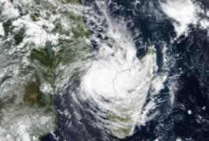
The United Nations Office for Outer Space Affairs (UNOOSA), as part of the support it provides to Member States through its UN-SPIDER programme, has requested the activation of the International Charter "Space and Major Disasters" for monitoring the impact of Cyclone Idai in Zimbabwe, which hit the country's eastern provinces on 15 and 16 March. The Charter was activated on behalf of the United Nations Development Programme (UNDP) Zimbabwe country office.
Following its landfall in Mozambique on 14 March, Cyclone Idai continued across land with heavy rains and strong winds that…
read more on the Suomi NPP satellite acquired this image of the cyclone on March 11, 2019, as it spun across the Mozambique Channel. Image: NASA.")
The United Nations Office for Outer Space Affairs (UNOOSA), as part of the support it provides to Member States through its UN-SPIDER programme, has requested the activation of the International Charter "Space and Major Disasters" for monitoring the impact of Cyclone Idai in Zimbabwe, which hit the country's eastern provinces on 15 and 16 March. The Charter was activated on behalf of the United Nations Development Programme (UNDP) Zimbabwe country office.
Geospatial experts from UNDP in Zimbabwe will…
read more18/03/2019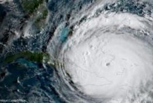
Understanding Risk (UR) Caribbean will be held from 27 May to 1 June 2019 at the University of the West Indies (UWI) Cave Hill Campus’ Errol Barrow Center for Creative Imagination. The event consists of three conference days of plenaries, technical sessions and cultural activities, followed by two days of workshops and side events. It provides space for multimedia exhibits and bilateral meetings.
Following the devastation caused by Hurricanes Irma and Maria in 2017 across the Caribbean, there has been increased emphasis on identifying, assessing and reducing disaster risk in the region. UR Caribbean will provide an informal platform for the public and private sectors, regional disaster risk management agencies, non-governmental organizations, multilateral development banks and donors across the Organization of Eastern Caribbean States, Caribbean Community, and Overseas Countries and Territories to:
- Identify gaps and needs that exist in disaster risk…
The training date is in the past. However, videos and resources of the training can be accessed here.
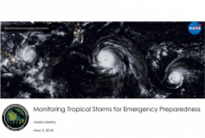
Tropical storms have major impacts, including loss of life and destruction of property. In 2017 alone, the United States experienced three tropical storms with more than $1 billion in losses. Open source satellite data can be used before, during, and after a storm for monitoring and response. A storm’s intensity, path, wind, precipitation, storm surge, and flooding can be derived from historical and near real-time satellite observations. In this introductory webinar, participants will learn about the NASA data and tools they can use to monitor tropical storms.
By the end of the training, attendees will be able to:
- Identify remote sensing data and tools relevant to tropical storms
- Monitor…
 ESA's Earth Observation Thematic Exploitation Platform (TEP) is a browser for satellite imagery and specific products on an environmental topic. The TEP platforms are divided into 7 categories: Coastal; Forstry; Geohazards; Hydrology; Polar; Urban; and Food Security. Each platform is a collaborative, virtual work environment providing access to EO data and the tools, processors and Information and Communication Technology resources required to work with them. TEP aims to bridge the gap between the users and the data and tools.Publishing institution:
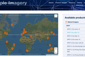 Pleidas, TerraSar-X, SPOT and Elevation data available commercially from airbus, certain sample data sets at various locations available for free.Publishing institution:
Term Parents
UN-SPIDER Regional Support Offices with hazard-specific expertise
![]()