
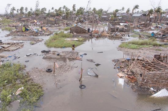
Disasters cause tremendous damage to societies around the world. They lead to loss of lives and property, displace people from their homes and destroy livelihoods, and disrupt sustainable development efforts worldwide. Developing countries are particularly susceptible to the impact of natural hazards as they are more vulnerable and exposed, and less resilient.
Through its spatial and temporal coverage, satellite-based information provides insights about disaster risks as well as about emergency situations when disasters occur. It supports all disaster management phases – prevention, mitigation, preparedness, response, rehabilitation, reconstruction and recovery – with the aim of avoiding impacts that may jeopardize development efforts. In combination with in situ observations and data from other sources, space-based information enables evidence-based decision making for sustainable development.
While an increasing number of African countries are developing space programmes, many countries on the continent do not have easy access to space-based information and knowledge about how to benefit from such data it in the context of disaster management and emergency response. For instance, the number of national organizations authorized to request the activation of the International Charter Space and Major Disasters, an international mechanism providing space-based information during disasters, is significantly lower than on any other continent.
In 2019, the United Nations Office for Outer Space Affairs, through its UN-SPIDER programme, and the Centre for Remote Sensing of Land Surfaces of the University of Bonn (ZFL) have launched the SPEAR project to understand needs, develop solutions and strengthen national capacities in using space-based information for disaster monitoring and prevention in Africa in line with international and regional frameworks.
Launch of the second project phase (SPEAR II)
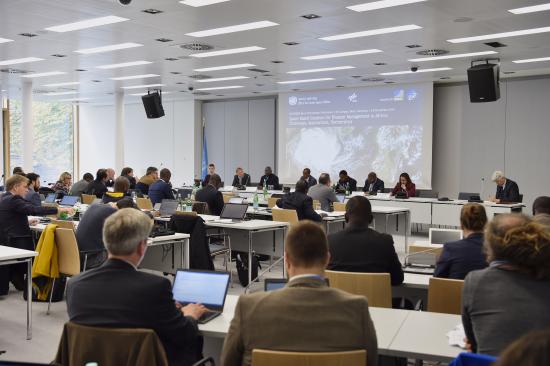
The COVID-19 pandemic and the increasing frequency and intensity of climate induced socio-natural hazards stress the need for more space-based solutions for disaster risk reduction. Taking note of the need to continue facilitating the use of space-based data, information, products and services to address the challenges posed by socio-natural and anthropogenic hazards, UN-SPIDER and ZFL are continuing to join forces to implement a second phase of the SPEAR project between 2024 and 2029. The SPEAR II project, supported by the German Aerospace Center (DLR), will allow UN-SPIDER and ZFL to further bridge the gap between the disaster management and the space communities, to provide advisory support to African countries, continue knowledge management efforts and raise awareness for space-based solutions.
Some of the main objectives of the project are:
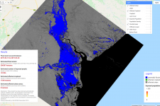
- The provision of solid methods for multi-hazard characterization and monitoring (manifestation, intensity, frequency) by improving existing approaches based on time series analysis of medium-resolution data including monitoring of historical events as well as integration of optimized spectral and geometric resolution of Sentinel-1, Sentinel-2 and Sentinel-3 data (time series analysis, data fusion, regional downscaling).
- Strengthened use of Earth Observation based data for the multi-hazard and multi-disaster-monitoring.
- Development of country-specific information for drought and flood prone regions in Africa, considering biophysical and socio-economic preconditions and cascading effects, represent the main basis for the technical advisory service missions (TAM) which are conducted with support by UN-SPIDER in the project’s pilot countries.
- The development of methods to integrate biophysical and socio-economic data analysis to improve information on vulnerability and exposure in consensus with international conventions and initiatives.
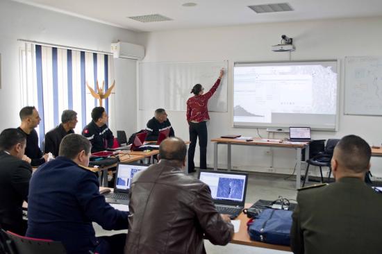
To achieve these objectives, various activities are carried out, such as expert meetings, missions to partner RSOs in Africa, international conferences and (virtual) workshops, and the University of Bonn conducts research on space-based solutions for disaster management.
The scientific outcomes of the project will be integrated into the TAMs and will be incorporated into training programs in the countries to promote and facilitate the use of free and open data and tools, leveraging Earth observation information and knowledge of its application. This is further supported by the development of best practices tailored to national needs in the field of disaster risk management.
More information about ZFL’s research can be found here: https://www.zfl.uni-bonn.de/research/projects/closed-projects/spear
The SPEAR project is funded by the German Federal Ministry for Economic Affairs and Energy (BMWi; grant No 50EE1804).
 | Background Information The project aims to understand user needs, develop solutions and strengthen institutional capacities in using space-based information for disaster monitoring and prevention. It focuses on Member States in Africa in line with international and regional frameworks such as the 2030 Agenda for Sustainable Development, the Sendai Framework for Disaster Risk Reduction 2015-2030 and the Agenda 2063 of the African Union. |
 | News On this page, we will post news about activities conducted as part of the project. |
 | Scientific advances This page presents information about Earth observation-based methods to strengthen disaster management developed as part of the project. |
 | Events On this page, you will find information on recent and upcoming conferences and expert meetings organized by UN-SPIDER and ZFL as part of the project. |