Major agricultural economies are among countries putting in place social distancing and lockdown measures to try contain the outbreak. However, these measures are having a negative impact on food production.
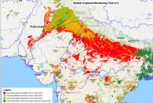
Satellite technology can efficiently help with agricultural planning. Satellite data can help ease travel restrictions to ensure sufficient labour and machinery are in place when crops are ready to harvest. It could assist authorities plan rotations to ensure everyone gets a turn at selling their produce at market. It can also support governments in stopping foods from going to waste in the fields.
To date, there are various free satellite data, such as Google Earth Engine, Nasa’s Landsat and MODIS, and the European Space Agency’s (ESA’s) Sentinel 1 and 2 data. Since this data is free and easy accessible, it can benefit especially less-equipped and less-financed economies, which might not have alternative resources to monitor food production.