![]()
United
Nations
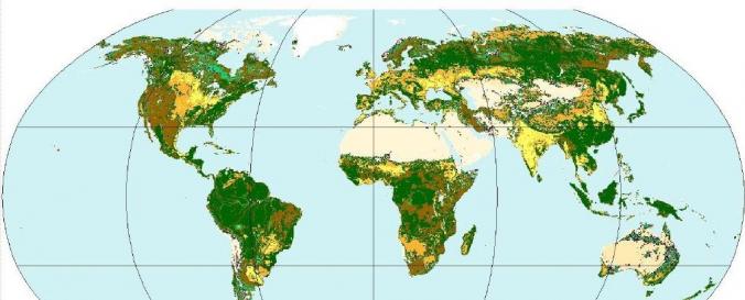
Land Cover Map (GLC-SHARE, FAO)
| Data provided by: | Food and Agriculture Organization of the United Nations (FAO) |
| Data accessibility: | export data |
| Link to the data: | |
| Data type: | land use, land cover data |
| Disaster cycle phase: | Disaster Risk Management |
| Spatial coverage: | Global |
| Spatial resolution: | 1000.00 m |
| Temporal coverage: | Archive |
| Content dates: | 1998-2012 |
| Technical Specifications: | |
| Costs: | free |
| Contact: | Contact GLC-SHARE at FAO, Rome |
| Restrictions/ Citation of the dataset: | Copyright: Exclusive right to the publication, production, or sale of the rights to a literary, dramatic, musical, or artistic work, or to the use of a commercial print or label, granted by law for a specified period of time to an author, composer, artist, distributor. Reproduction and dissemination of material contained in GLC-SHARE Beta-Release v1.0 or educational, research, personal or other noncommercial purposes are authorized without any prior written permission from the copyright holders, provided FAO are fully acknowledged. No part of GLC-SHARE Beta-Release v1.0 data may be downloaded, stored in a retrieval system or transmitted by any means for resale or other commercial purposes without written permission of the copyright holders. If any information or resources on this site are attributed to a site or source external to FAO permission to use must be sought with FAO. |
Provider
![]()