  • English
  • Español
  • Français

United
Nations


Office for Outer Space Affairs
UN-SPIDER Knowledge Portal

  • Home
  • About Us
    • What is UN-SPIDER?
    • About UNOOSA
    • Publications
    • Jobs
    • Meet the Team
    • Contact
  • Space Application
    • Satellite Technology
    • Emergency Mechanisms
    • Recovery Mechanisms
    • International Asteroid Warning Network
    • Space Mission Planning Advisory Group
    • International Space Weather Initiative
    • Space Technologies in the UN
    • User Stories
  • Links & Resources
    • Data Applications
      • Disaster Recovery
    • Data Sources
    • GIS and Remote Sensing Software
    • Online Learning Resources
    • Institutions
  • Risks & Disasters
    • Disaster Risk Management
    • Early Warning Systems
    • Emergency and Disaster Management
    • Natural Hazards
    • Sendai Framework
    • The UN and Disaster Risk Management
    • The UN and Early Warning
    • The UN and Disaster Management
  • Advisory Support
    • Advisory Missions
    • Emergency Support
    • Virtual Advisory Support
    • Recommended Practices
    • Training Activities
    • Practical Uses
  • Network
    • Regional Support Offices
    • GP-STAR
    • MHEWS
    • IWG-SEM
  • Projects
    • SPEAR
    • SEWS-D
    • EvIDENz
    • Flood GUIDE
  • News & Events
    • News
    • Events Calendar
    • UN-SPIDER Events Archive
  • Admin
    • SAM Items

Breadcrumb

  • Home
  • News and Events
  • View Active News
  • Ash From Puyehue-Cordón Caulle Over Australia and New Zealand
  • Ash from Puyehue-Cordón Caulle over Australia and New Zealand

Ash from Puyehue-Cordón Caulle over Australia and New Zealand

The eruption at Chile’s Puyehue-Cordón Caulle Volcanic Complex sent clouds of ash high into the atmosphere, above the weather that usually breaks up such plumes. The CALIPSO satellite recorded the plume 15 kilometers (50,000 feet) above the Earth on the second day of the eruption, and the volcano continues to push ash into the atmosphere. At these high altitudes, the ash entered the jetstream and blew quickly eastward.

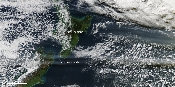
By June 13, when the Moderate Resolution Imaging Spectroradiometer (MODIS) on the Aqua satellite acquired these images, a concentrated plume was visible more than half a world away over Australia and New Zealand. The top image shows the ash plume over southern Australia and the Tasman Sea, while the lower image provides a view farther east over New Zealand and the South Pacific Ocean.

The Civil Aviation Authority of New Zealand warned pilots that the ash cloud was between 20,000 and 35,000 feet (6 to 11 kilometers), the cruising level for many aircraft. Because volcanic ash can damage a jet engine, flight traffic in parts of Australia and New Zealand was canceled or diverted to lower altitudes.


NASA Earth Observation
Thu, 16 Jun 2011 - 16:18

Footer menu

  • Contact
  • Terms of Use

User account menu

  • Log in