• English
  • Español
  • Français

United
Nations


Office for Outer Space Affairs
UN-SPIDER Knowledge Portal

  • Home
  • About Us
    • What is UN-SPIDER?
    • About UNOOSA
    • Publications
    • Jobs
    • Meet the Team
    • Contact
  • Space Application
    • Satellite Technology
    • Emergency Mechanisms
    • Recovery Mechanisms
    • International Asteroid Warning Network
    • Space Mission Planning Advisory Group
    • International Space Weather Initiative
    • Space Technologies in the UN
    • User Stories
  • Links & Resources
    • Data Applications
      • Disaster Recovery
    • Data Sources
    • GIS and Remote Sensing Software
    • Online Learning Resources
    • Institutions
  • Risks & Disasters
    • Disaster Risk Management
    • Early Warning Systems
    • Emergency and Disaster Management
    • Natural Hazards
    • Sendai Framework
    • The UN and Disaster Risk Management
    • The UN and Early Warning
    • The UN and Disaster Management
  • Advisory Support
    • Advisory Missions
    • Emergency Support
    • Virtual Advisory Support
    • Recommended Practices
    • Training Activities
    • Practical Uses
  • Network
    • Regional Support Offices
    • GP-STAR
    • MHEWS
    • IWG-SEM
  • Projects
    • SPEAR
    • SEWS-D
    • EvIDENz
    • Flood GUIDE
  • News & Events
    • News
    • Events Calendar
    • UN-SPIDER Events Archive
  • Admin
    • SAM Items

Breadcrumb

  • Home
  • News and Events
  • View Active News
  • Canada: ISERV Camera On International Space Station Captures Floods In Calgary
  • Canada: ISERV camera on International Space Station captures floods in Calgary

Canada: ISERV camera on International Space Station captures floods in Calgary

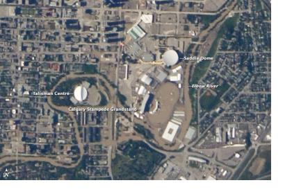
Image acquired June 22, 2013Image acquired June 22, 2013

The "disaster cam" installed in the Destiny module window on the International Space Station (ISS) in January 2013 by Canadian astronaut Chris Hadfield, captured digital images of downtown Calgary, Canada as is was inundated by floodwaters in June 2013. The camera is known as ISERV—the ISS SERVIR Environmental Research and Visualization System.

NASA specified: "The top photo was acquired on June 22, near the height of the flooding around the Saddledome and the venue for the Calgary Stampede. The lower image from June 24 shows sediment and debris deposited around the city as the waters receded. (Turn on the image comparison tool to see the difference.) Note that the June 24 image is slightly blurry because the ISS was passing slightly to the east, and the city was not centered below the fixed, downward pointing camera. Larger, downloadable images (linked beneath each image above) show the floodwaters from both the Bow and Elbow Rivers inundating the wider Calgary metropolitan area."
NASA
Mon, 1 Jul 2013 - 14:19

Footer menu

  • Contact
  • Terms of Use

User account menu

  • Log in