  • English
  • Español
  • Français

United
Nations


Office for Outer Space Affairs
UN-SPIDER Knowledge Portal

  • Home
  • About Us
    • What is UN-SPIDER?
    • About UNOOSA
    • Publications
    • Jobs
    • Meet the Team
    • Contact
  • Space Application
    • Satellite Technology
    • Emergency Mechanisms
    • Recovery Mechanisms
    • International Asteroid Warning Network
    • Space Mission Planning Advisory Group
    • International Space Weather Initiative
    • Space Technologies in the UN
    • User Stories
  • Links & Resources
    • Data Applications
      • Disaster Recovery
    • Data Sources
    • GIS and Remote Sensing Software
    • Online Learning Resources
    • Institutions
  • Risks & Disasters
    • Disaster Risk Management
    • Early Warning Systems
    • Emergency and Disaster Management
    • Natural Hazards
    • Sendai Framework
    • The UN and Disaster Risk Management
    • The UN and Early Warning
    • The UN and Disaster Management
  • Advisory Support
    • Advisory Missions
    • Emergency Support
    • Virtual Advisory Support
    • Recommended Practices
    • Training Activities
    • Practical Uses
  • Network
    • Regional Support Offices
    • GP-STAR
    • MHEWS
    • IWG-SEM
  • Projects
    • SPEAR
    • SEWS-D
    • EvIDENz
    • Flood GUIDE
  • News & Events
    • News
    • Events Calendar
    • UN-SPIDER Events Archive

Breadcrumb

  • Home
  • News and Events
  • View Active News
  • CATHALAC: Analysis On Fires In Central America
  • CATHALAC: Analysis on fires in Central America

CATHALAC: Analysis on fires in Central America

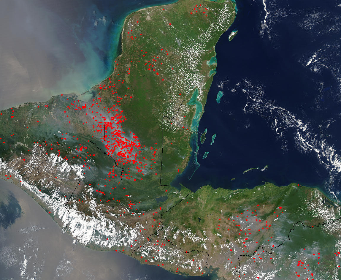
UN-SPIDER's Regional Support Office CATHALAC (Water Center for the Humid Tropics of Latin America and the Caribbean) published a new study about fires in Central America. The analysis was carried out in the context of SERVIR - a Regional Visualization and Monitoring System created by NASA, USAID, CATHALAC and other partners.

The analysis observed hotspots across Central America for the dry season 2012 using satellite imagery obtained from MODIS. For the period January till March 2012 5533 hotspots have been identified caused by agricultural fires, forest fires and volcanic activities representing possible hazards for loss of forest or threatening vulnerable areas. 17 percent of the hotspots are suspected to be forest fires.

SERVIR
Mon, 16 Apr 2012 - 11:21
Water Center for the Humid Tropics of Latin America and the Caribbean (CATHALAC)

Footer menu

  • Contact
  • Terms of Use

User account menu

  • Log in