• English
  • Español
  • Français

United
Nations


Office for Outer Space Affairs
UN-SPIDER Knowledge Portal

  • Home
  • About Us
    • What is UN-SPIDER?
    • About UNOOSA
    • Publications
    • Jobs
    • Meet the Team
    • Contact
  • Space Application
    • Satellite Technology
    • Emergency Mechanisms
    • Recovery Mechanisms
    • International Asteroid Warning Network
    • Space Mission Planning Advisory Group
    • International Space Weather Initiative
    • Space Technologies in the UN
    • User Stories
  • Links & Resources
    • Data Applications
      • Disaster Recovery
    • Data Sources
    • GIS and Remote Sensing Software
    • Online Learning Resources
    • Institutions
  • Risks & Disasters
    • Disaster Risk Management
    • Early Warning Systems
    • Emergency and Disaster Management
    • Natural Hazards
    • Sendai Framework
    • The UN and Disaster Risk Management
    • The UN and Early Warning
    • The UN and Disaster Management
  • Advisory Support
    • Advisory Missions
    • Emergency Support
    • Virtual Advisory Support
    • Recommended Practices
    • Training Activities
    • Practical Uses
  • Network
    • Regional Support Offices
    • GP-STAR
    • MHEWS
    • IWG-SEM
  • Projects
    • SPEAR
    • SEWS-D
    • EvIDENz
    • Flood GUIDE
  • News & Events
    • News
    • Events Calendar
    • UN-SPIDER Events Archive

Breadcrumb

  • Home
  • News and Events
  • View Active News
  • CATHALAC Publishes Satellite Imagery of Guatemala Volcano Eruption
  • CATHALAC publishes satellite imagery of Guatemala volcano eruption

CATHALAC publishes satellite imagery of Guatemala volcano eruption

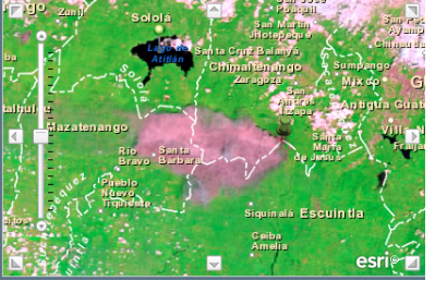
Ash cloud following the eruption captured by NASA 10:30 a.m. local time on 13 September 2012.

UN-SPIDER's Regional Support Office CATHALAC (Water Center for the Humid Tropics of Latin America and the Caribbean) quickly reacted to yesterday's eruption of Guatemala's Fuego Volcano. In the context of SERVIR, the experts published a preliminary analysis of the volcano eruption including NASA MODIS satellite imagery, NOAA GOESS data as well as prognostics on winds and further volcanic activities. Additionally, via CATHALAC's GeoViewer, several pre- and post-disaster images are available tracking the development of the ash cloud. These 14 departments are affected by the ash cloud covering 89,460 hectares of land: Santiago Atitlán, San Lucas Tolimán, Chicacao, Pochuta, Acatenango, Santa Barbara, Patulul, Yepocapa, Alotenango, Rio Bravo, San Juan Bautista, Escuintla, Siquinalá y Santa Lucia Cotzumalguapa.

After the strong eruption of the Fuego volcano on 13 September 2012, Guatemala has evacuated thousands of people after the volcano started spewing ash and lava. Volcanologists said powerful eruptions were catapulting burning rocks as high as 1,000m above the crater and lava was flowing down its slopes. Experts say the eruption of the Fuego, 50km south-west of Guatemala City, is the biggest since 1999.
Fri, 14 Sep 2012 - 07:33
Guatemala
Water Center for the Humid Tropics of Latin America and the Caribbean (CATHALAC)

Footer menu

  • Contact
  • Terms of Use

User account menu

  • Log in