  • English
  • Español
  • Français

United
Nations


Office for Outer Space Affairs
UN-SPIDER Knowledge Portal

  • Home
  • About Us
    • What is UN-SPIDER?
    • About UNOOSA
    • Publications
    • Jobs
    • Meet the Team
    • Contact
  • Space Application
    • Satellite Technology
    • Emergency Mechanisms
    • Recovery Mechanisms
    • International Asteroid Warning Network
    • Space Mission Planning Advisory Group
    • International Space Weather Initiative
    • Space Technologies in the UN
    • User Stories
  • Links & Resources
    • Data Applications
      • Disaster Recovery
    • Data Sources
    • GIS and Remote Sensing Software
    • Online Learning Resources
    • Institutions
  • Risks & Disasters
    • Disaster Risk Management
    • Early Warning Systems
    • Emergency and Disaster Management
    • Natural Hazards
    • Sendai Framework
    • The UN and Disaster Risk Management
    • The UN and Early Warning
    • The UN and Disaster Management
  • Advisory Support
    • Advisory Missions
    • Emergency Support
    • Virtual Advisory Support
    • Recommended Practices
    • Training Activities
    • Practical Uses
  • Network
    • Regional Support Offices
    • GP-STAR
    • MHEWS
    • IWG-SEM
  • Projects
    • SPEAR
    • SEWS-D
    • EvIDENz
    • Flood GUIDE
    • CommonSpace Initiative
    • Tonga Pilot Project
  • News & Events
    • News
    • Events Calendar
    • UN-SPIDER Events Archive

Breadcrumb

  • Home
  • News and Events
  • View Active News
  • Copernicus Newly Launched Coastal Hub
  • Copernicus Newly Launched Coastal Hub

Copernicus Newly Launched Coastal Hub

Image of Copernicus Coastal Hub homepage

The coastlines of the world host a rich mix of dense populations, varying industries, and environmental characteristics that are collectively influenced by both land and sea. To facilitate the production of knowledge and data products regarding these complex coastal regions, the European Commission under the Copernicus program has developed a new online resource: The Copernicus Coastal Hub. The Coastal Hub offers a singular resource for data related to coastal regions including examples of use cases and an interactive data and map viewer.

The site provides a number of different use cases for the application of coastal focused datasets within the repository that could inform data-driven decision making within various sectors of research, government, and private industry. These uses are divided into three themes, water, pollution, and spatial planning, and include examples and case studies of the uses of coastal data in different parts of the world. For the disaster risk management community, the site offers examples of data used for hazard mapping, risk assessment, preparedness assessment, and applications for specific hazards such as flooding, drought, tsunamis, and coastal erosion. These specific use cases can further be elaborated upon by the information hosted in the Coastal Hubs data viewer. 

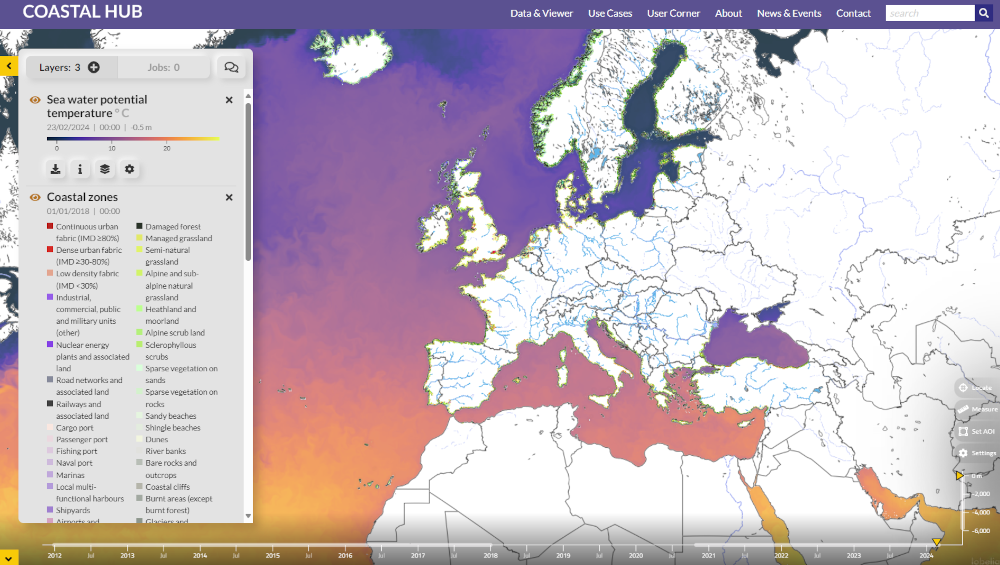
The Costal Hub Data Viewer is a tool that offers both an extensive list of coastal data products hosted by the website, and a visualization tool for quick representation of these products. It currently hosts a number of data products such as past flood risk indicators for Europe, forecasts for river discharge, water level change, ocean wave analysis, and many more. These datasets and their associated layers can be quickly mapped using the Data Viewer and then requested for download. 

Coastal Hub Data View
Copernicus Coastal Hub Homepage
Fri, 23 Feb 2024 - 15:00
Europe

Footer menu

  • Contact
  • Terms of Use

User account menu

  • Log in