In recent years, wildfires have become a growing global concern, with climate change-driven extreme weather contributing to their increasing frequency and severity. Regions from Canada to Australia and the Mediterranean have seen devastating impacts, including loss of life, destruction of property, and significant atmospheric emissions. As the risk of wildfires intensifies, advanced monitoring systems like the Copernicus Atmosphere Monitoring Service (CAMS) and Copernicus Climate Change Service (C3S) are playing a crucial role in understanding and responding to these fires.
To monitor and assess the impacts of wildfires, one key metric used is Fire Radiative Power (FRP). FRP quantifies the rate at which energy is radiated from a fire, providing valuable insights into the fire's intensity. Satellites equipped with sensors, including NASA's Terra and Aqua satellites, and the Sentinel satellites, measure the brightness temperature of Earth's surface to calculate FRP. This data is then utilized by CAMS’s Global Fire Assimilation System (GFAS) to estimate emissions of pollutants related to burning vegetation, helping researchers and fire managers gauge the severity and progression of wildfires.
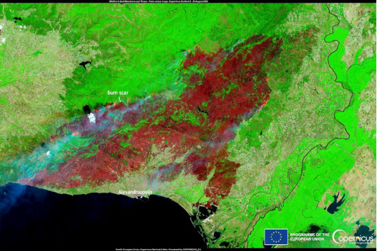
Another critical measure is the burned area, which refers to the territory affected by wildfires. Satellite imagery and remote sensing techniques are essential in calculating the extent of these burned areas. The European Forest Fire Information System (EFFIS) uses data from the MODIS instruments and Sentinel-2 satellites to map these areas, providing accurate assessments of the damage caused by wildfires across Europe.
The link between climate change and the rising threat of wildfires is evident, with factors such as higher global temperatures, prolonged droughts, and altered wind patterns increasing the risk of fires. Moreover, there is a feedback loop where wildfires contribute to climate change by releasing large amounts of carbon, reducing the carbon storage capacity of land, and altering the Earth's radiation balance.
CAMS and C3S provide extensive data on wildfire activity, emissions, and smoke transport, offering valuable resources for researchers, meteorologists, and fire managers. By leveraging these tools, the global community can better understand and respond to the increasing wildfire threat, ultimately working towards reducing the devastating impacts of these natural disasters.
Find more details and information in the original article published by the Copernicus Climate Change Service.
Image: Sentinel-2 data showing the burn scar in East Macedonia and Thrace near Alexandropoulis on 23 August 2023. Source: European Union, Copernicus Sentinel-2 imagery