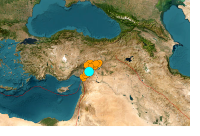
A major earthquake of magnitude 7.8 struck Turkey with epicentre on 23 kilometres east of Nurdagi (Gaziantep Province) on February 6, 2023. By the activity spreading to adjacent faults, the region was hit by a 6.7- magnitude and a 7.5- magnitude aftershocks respectively. The earthquake also affected neighbouring Syria.
The space community is also taking action through the activation of the International Charter on Space and Major Disasters. The charter provides a mechanism for the provision of satellite data to support the relief efforts of disaster-stricken areas. The Copernicus Emergency Management Service (EMS) has also been activated to provide support to the affected countries.
The use of space-based information can greatly assist in disaster response efforts. Satellites can provide detailed images and maps of the affected area to help search and rescue teams identify areas in need of assistance. They can also provide information on the extent of the damage, helping decision-makers prioritize relief efforts.
In the case of the earthquake in Turkey and Syria, the space community is working together to provide critical information and support to the affected countries. Through the activation of the International Charter on Space and Major Disasters, and the Copernicus Emergency Management Service, the space community is playing an important role in the response and recovery efforts. Moreover, a Chinese SAR operator contacted UN-SPIDER to offer post-disaster imagery to support relief efforts.
Links
General Information:
- https://www.space.com/turkey-earthquake-united-nations-emergency-mapping-satellite
- https://theconversation.com/earthquake-in-turkey-and-syria-how-satellites-can-help-rescue-efforts-199357
- https://www.usgs.gov/news/featured-story/magnitude-78-earthquake-nurdagi-turkey
International Charter Space & Major Disasters Activation
- Turkey: https://disasterscharter.org/web/guest/activations/-/article/earthquake-in-turkey-activation-797-
- Syria: https://disasterscharter.org/web/guest/activations/-/article/earthquake-in-syrian-arab-republic-activation-798-
Copernicus Activation
UNITAR-UNOSAT Activity
Image Sources: USGS. Earthquakes that have occurred since Sunday afternoon, February 5, in the region. In blue, the 7.8 magnitude earthquake. In orange, the numerous aftershocks: the size of the disc indicates the magnitude.

