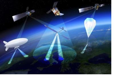
The European Space Agency is currently conducting a more in-depth examination into the concept of High Altitude Pseudo Satellites (HAPS) and their potential for emergency response. HAPS are aircraft which are flying or floating at around 20 km altitude for very long duration flights up to several months or even years. Flying at a similar altitude as conventional aircraft but operating more like satellites they are able to offer continuous coverage of the territory below and are considered as the “missing link” between drones and satellites.
Even though the concept of HAPS has been looked into for around 20 years the reason that they are about to become reality only now is the maturing of key technologies like miniaturised avionics, high-performance solar cells, lightweight batteries, miniaturisation of Earth observation sensors and high-bandwidth communication links that can deliver competitively priced services.
Above the clouds and jet streams, and around 10 km above commercial airliners, wind speeds are low enough for HAPS to hold their position for long periods so that it is possible to extensively survey the ground to the horizon 500 km away.
Facilitating precise monitoring and surveillance, high-bandwidth communication or backup to existing satellite navigation services HAPS can be used for several purposes such as telecommunication, emergency/public safety communications, intelligent transportation systems, maritime surveillance, environmental monitoring, land border control applications, et cetera.
Of special interest for the disaster management and emergency response community is the obvious potential of HAPS for their efforts. Besides being employed in immediate cases they could, for instance, also be used semi-permanently, extending satellite navigation coverage into both remote and inaccessible places like narrow valleys.

