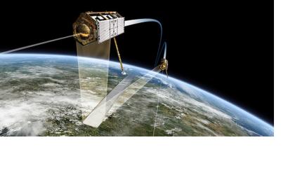
A conference of geological and scientific experts met in the southern Chilean city of Punta Arenas last week to discuss using the TerraSAR-X satellite system to assist Chile in predicting volcanic eruptions. The satellite, which has been in orbit for nearly a year, could provide Chile with significantly advanced warning of volcanic activity and tsunamis.
The TerraSAR-X satellite has primarily been used to observe the changing landscape and climate of Antarctica. The satellite can track changes in Antarctic ice masses, including thinning glaciers and changes to the ozone layer, almost in real time.
The satellite works in tandem with Chile’s General Bernardo O’Higgins Base, located in Antarctica, where the data is downloaded and analyzed.
In the wake of recent volcanic eruptions, Chile is working to improve natural disaster preparedness by extending its volcano monitoring network.
The primary advantage of the TerraSAR-X satellite is its capacity to see through natural obstructions like ash, and to compensate for low visibility in certain weather conditions at any time of day. These advantages were exemplified following the June eruption of the Cordón Caulle volcanic complex in southern Chile.
Dr. Stefan Dech, director of German Remote Sensing Data Center (DFD), part of the German Aerospace program, told El Mercurio of the TerraSAR-X satellite’s advantages in tracking the eruption: “ash clouds only minimally disrupt radar signals, such that the TerraSAR-X satellite provides a virtually unhindered view of the volcanic structure.”
At the Punta Arenas conference, scientists discussed the next step in developing an early warning system for volcanoes. By coordinating the TerraSAR-X and Tandem-X satellites, they will be better able to observe active volcanoes like Chile’s Hudson volcano.
Using these two satellites to measure shifts in the earth and temperature changes, scientists will be able to better predict volcanic eruptions. This will allow a larger window for evacuation of local communities
“Shortly before a volcano erupts it is possible to see how gases beneath the earth’s surface inflate the ground,” Dech told El Mercurio. “The satellites can monitor this and it serves as an early indicator of a volcanic eruption.”
The DFD also hopes to use its technologies to assist Chile in developing a tsunami warning system. They look to replicate an early warning system they currently use in the Indian Ocean in partnership with Chile’s Navy Hydrographic Service (SHOA).
Dech went on to tell El Mercurio, “I’m very optimistic that we will launch a project with SHOA and Onemi [Chile’s Interior Ministry of Public Security] in the coming months to jointly develop an information system for natural disasters.”

