
Introduction
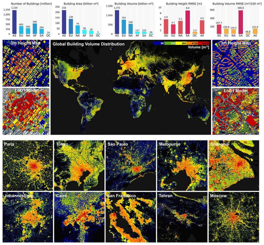
Buildings are among the most important elements represented in digital twins, urban planning systems and disaster risk management platforms. Accurate information on building location, size and height helps decision makers understand population exposure, assess infrastructure vulnerability, estimate economic losses and monitor urban development. Despite their importance, complete and consistent global building datasets have historically been difficult to obtain. Many available datasets cover only specific countries or cities, while others provide building footprints but lack height information needed for three-dimensional analysis. To address this gap, researchers from the Technical University of Munich (TUM) developed Global Building Atlas (GBA), an open global dataset providing building footprints, building heights and Level of Detail 1 (LoD1) 3D building models at the individual-building scale. Published in 2025 by Dr. Zhu and her team, GBA represents one of the most comprehensive open building datasets currently available worldwide.
Why Building Data Matters
Building information forms the foundation of many geospatial applications. For disaster risk management, building datasets support:
- Exposure and vulnerability assessments
- Flood and tsunami impact analysis
- Earthquake risk modelling
- Population distribution studies
- Critical infrastructure planning
- Emergency response and recovery operations
For digital twin applications, building data provides:
- Three-dimensional city visualization
- Urban growth monitoring
- Infrastructure management
- Climate adaptation modelling
- Sustainable development planning
While a two-dimensional building footprint shows where a building exists, building height data provides information about urban density, building volume, and vertical development patterns. These characteristics are essential for realistic digital twin environments and advanced disaster risk analyses.
What Is GlobalBuildingAtlas?
GlobalBuildingAtlas consists of three complementary products; see the table below. Together, these datasets provide a consistent global representation of the built environment suitable for large-scale geospatial analysis and digital twin development.
Dataset | Description | Coverage / Key Metric |
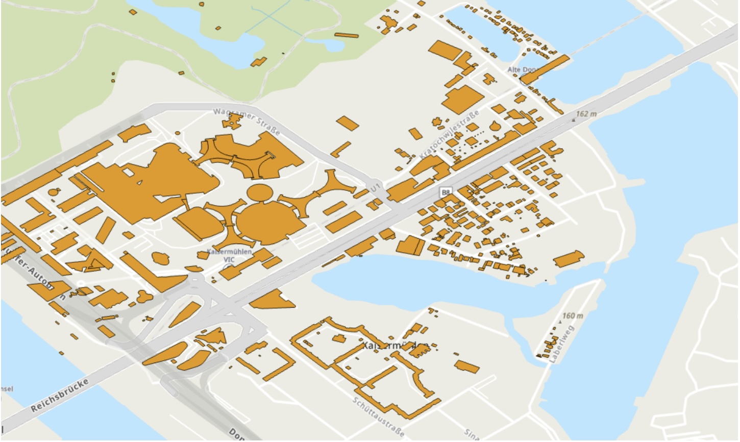
| GBA.Polygon | A global building footprint dataset containing building polygons. | Approximately 2.75 billion building polygons |
| GBA.Height | A global building height raster generated at high spatial resolution, providing one of the finest-resolution global building-height products currently available. | 3-meter spatial resolution |
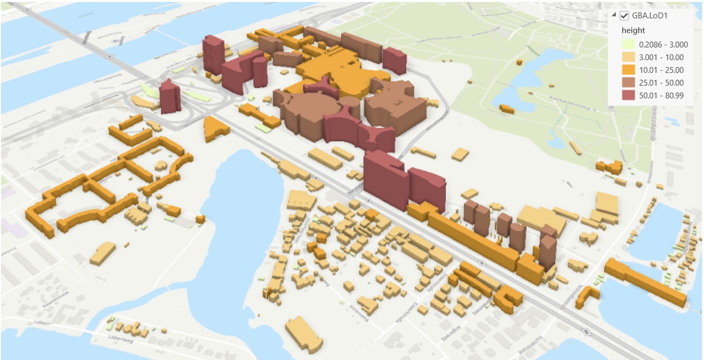
| GBA.LoD1 | A global collection of LoD1 3D building models with assigned height information. | Approximately 2.68 billion LoD1 3D building models, representing more than 97% of mapped buildings with height information |
How the Dataset is Created
One of the most significant contributions of GlobalBuildingAtlas is the methodology used to generate the data. Unlike many existing products that rely heavily on local mapping campaigns or extensive LiDAR coverage, GBA uses globally available optical satellite imagery combined with artificial intelligence. The production workflow consists of three major stages:
Building Footprint Generation
Dr. Zhu and her team collected approximately 800,000 PlanetScope satellite image scenes covering built-up areas worldwide at a spatial resolution of 3 meters. To process this large-scale dataset, the imagery is passed through a deep-learning building extraction framework driven by two primary network architectures:
- ConvNeXt-Tiny Backbone Network: Extracts multi-scale visual features from the input satellite imagery.
- UPerNet Encoder-Decoder Architecture: Performs semantic segmentation to decode those features into spatial predictions.
Working in tandem, this pipeline first identifies building pixels within each satellite scene to generate raw binary building masks. Because adjacent structures often visually merge together at moderate resolutions, a secondary regularization network refines the structural boundaries and enhances individual building separation. Finally, these processed masks are converted into vector polygons, filtered to eliminate false positives, and prepared for integration into the global inventory.
Building Height Estimation
The second AI pipeline estimates building heights directly from monocular optical satellite imagery. Height estimation is powered by an HTC-DC Net (Head-Tail Cut with Distribution-based Constraints Network) framework trained on two key datasets:
- PlanetScope Satellite Imagery: 3-meter spatial resolution optical scenes capturing global built-up areas.
- Airborne LiDAR-derived Height Maps (nDSMs): High-precision normalized Digital Surface Models used only to train the model.
The model learns spatial and contextual cues—such as shadow geometry, building footprints, and structural textures—that correlate with height in regions where LiDAR data is available. Once trained, it predicts building heights globally using only optical PlanetScope imagery, outputting GBA.Height, a continuous 3-meter spatial resolution raster.
Rather than relying solely on AI-generated footprints, the pipeline executes a quality-guided data fusion strategy that merges model outputs with four major open building datasets:
- OpenStreetMap (OSM)
- Google Open Buildings
- Microsoft Building Footprints
- CLSM (Comprehensive Large-Scale Mapping) Building Dataset
This fusion algorithm dynamically ranks and selects the optimal footprint source for each geographic region, supplementing primary sources with secondary datasets to maximize spatial completeness, eliminate coverage gaps, and resolve local boundary errors.
Creation of LoD1 Models
Finally, building heights are derived from GBA. Heights are assigned to individual building footprints. Each footprint is extruded vertically using its corresponding height estimate, creating a simple three-dimensional representation known as a Level of Detail 1 (LoD1) model.
Understanding LoD1–LoD3
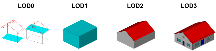
Digital twin projects often describe buildings using Levels of Detail (LoD). GlobalBuildingAtlas provides LoD1 models because they can be generated consistently at global scale while maintaining manageable storage and processing requirements. Open Geospatial Consortium (OGC) provides LoD details through City Geography Markup Language (CityGML) v3.
| LoD | Key Characteristics | Common Applications |
| LoD0 | 2D footprint or roof edge polygons | Regional GIS mapping |
| 2D/2.5D terrain profiles without volumetric extrusion | Spatial zoning & land administration | |
| Includes 2D interior floor plans and room boundaries | 2D cadastral modeling | |
| LoD1 | Single height extrusion forming prismatic "block" models | Regional and national urban analysis |
| Flat top roof representation | Global energy demand & climate exposure modeling | |
| Supports coarse interior volume modeling (e.g., storey/building block spaces) | Macro-scale disaster management | |
| LoD2 | Multi-pitch roof geometry and distinct roof structures | Solar potential & shading studies |
| Simplified exterior boundary walls | Urban microclimate & wind flow modeling | |
| Decoupled interior spaces mapped alongside realistic roof shapes | City-wide 3D visualisations | |
| LoD3 | Detailed architectural exterior (façades, windows, doors, wall openings) | Detailed urban design & micro-simulations |
| Fully integrated high-detail interior geometry (formerly LoD4 capabilities) | Architectural conservation & heritage | |
| Direct harmonization with BIM / IFC models | BIM-to-GIS integration & facility management |
The Figures of LoD:
Accuracy and Limitations
The authors report that the generated LoD1 models achieve building-height Root Mean Square Errors (RMSEs) ranging between approximately 1.5 and 8.9 meters, depending on continent and test region. However, several limitations should be considered.
Temporal Limitations
The dataset primarily represents satellite images around 2019, with some areas supplemented using imagery from 2018. New developments occurring after this period may not be represented.
Geographic Bias
Height estimation models were trained primarily using LiDAR data from North America, Europe and Oceania. The paper notes limited availability of training data in regions such as Africa.
As a result, building-height accuracy may vary geographically, particularly in underrepresented regions and rapidly growing urban areas.
LoD1 Simplification
The dataset provides building blocks rather than detailed architectural representations. Roof geometry, façade details and building interiors are not included.
Relevance for Disaster Risk Reduction
GlobalBuildingAtlas offers several opportunities for disaster risk applications:
- Exposure mapping in data-sparse regions
- Flood and tsunami risk assessments
- Earthquake impact modelling
- Urban growth and land-use monitoring
- Population and infrastructure analyses
- Baseline digital twin development
The dataset is particularly valuable in regions where authoritative building inventories are unavailable or incomplete. For many countries, especially Small Island Developing States (SIDS) and Least Developed Countries (LDCs), GlobalBuildingAtlas can provide an accessible starting point for developing national geospatial information systems and digital twins. However, where high-precision engineering analyses are required, the dataset should be supplemented with local surveys, LiDAR observations, or national mapping products.
Accessing the Data
GlobalBuildingAtlas data are available through the project's official repositories:
- GitHub: https://github.com/zhu-xlab/GlobalBuildingAtlas
- mediaTUM Repository
- Hugging Face Dataset Repositories
The data are distributed in standard geospatial formats including:
- GeoJSON
- GeoPackage
- Parquet
- GeoTIFF
Conclusion
GlobalBuildingAtlas represents a major advancement in open global building mapping. By combining satellite imagery, artificial intelligence and open geospatial datasets, the project delivers one of the most complete global inventories of building footprints, heights and LoD1 3D models currently available.
For digital twins, disaster risk reduction, sustainable development and urban analytics, the dataset provides an unprecedented global baseline of the built environment. While limitations related to temporal coverage and regional accuracy remain, GlobalBuildingAtlas offers a valuable resource for organizations seeking consistent and openly accessible building information at global scale.
References
- Zhu, X.X., Chen, S., Zhang, F., Shi, Y., & Wang, Y. (2025). GlobalBuildingAtlas: an open global and complete dataset of building polygons, heights and LoD1 3D models. Earth System Science Data, 17, 6647-6668. https://doi.org/10.5194/essd-17-6647-2025
- GlobalBuildingAtlas Project Repository. https://github.com/zhu-xlab/GlobalBuildingAtlas
