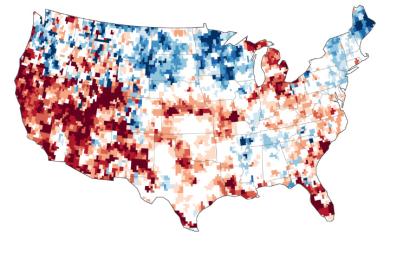
In a new study by NASA and University of California, Irvine, several maps combining data from the satellites of NASA's Gravity Recovery and Climate Experiment (GRACE) with other satellite and ground-based measurements modeled the quantity of groundwater in the Colorado River Basin. The scientists found our that more than 75 percent of the water lost since 2004 in the drought-stricken Colorado River Basin has come from underground sources.
Scientists at NASA have used GRACE data to map the groundwater deficit in the entire United States. The satellite data helped to get a clear picture on the water amount below the surface. The pumping from underground aquifers is regulated by individual states and is often not well documented. "There's only one way to put together a very large-area study like this, and that is with satellites," said senior author Jay Famiglietti, a senior water cycle scientist. "There's just not enough information available from well data to put together a consistent, basin-wide picture."
NASA explains how the gravity satellite can detect underground water: "Within a given region, the change in mass due to rising or falling water reserves influences the strength of the local gravitational attraction. By periodically measuring gravity regionally, GRACE reveals how much a region's water storage changes over time."

