  • English
  • Español
  • Français

United
Nations


Office for Outer Space Affairs
UN-SPIDER Knowledge Portal

  • Home
  • About Us
    • What is UN-SPIDER?
    • About UNOOSA
    • Publications
    • Jobs
    • Meet the Team
    • Contact
  • Space Application
    • Satellite Technology
    • Emergency Mechanisms
    • Recovery Mechanisms
    • International Asteroid Warning Network
    • Space Mission Planning Advisory Group
    • International Space Weather Initiative
    • Space Technologies in the UN
    • User Stories
  • Links & Resources
    • Data Applications
      • Disaster Recovery
    • Data Sources
    • GIS and Remote Sensing Software
    • Online Learning Resources
    • Institutions
  • Risks & Disasters
    • Disaster Risk Management
    • Early Warning Systems
    • Emergency and Disaster Management
    • Natural Hazards
    • Sendai Framework
    • The UN and Disaster Risk Management
    • The UN and Early Warning
    • The UN and Disaster Management
  • Advisory Support
    • Advisory Missions
    • Emergency Support
    • Virtual Advisory Support
    • Recommended Practices
    • Training Activities
    • Practical Uses
  • Network
    • Regional Support Offices
    • GP-STAR
    • MHEWS
    • IWG-SEM
  • Projects
    • SPEAR
    • SEWS-D
    • EvIDENz
    • Flood GUIDE
  • News & Events
    • News
    • Events Calendar
    • UN-SPIDER Events Archive

Breadcrumb

  • Home
  • News and Events
  • View Active News
  • Heavy Snow In Central Chile
  • Heavy Snow in Central Chile

Heavy Snow in Central Chile

In what the interior minister described as a “white earthquake,” heavy snow blanketed parts of Chile in July 2011. Snow was 2.3 meters (7.5 feet) deep in the city of Lonquimay, CNN reported. Santiago Times reported that some areas received four months’ worth of snowfall in just four days.

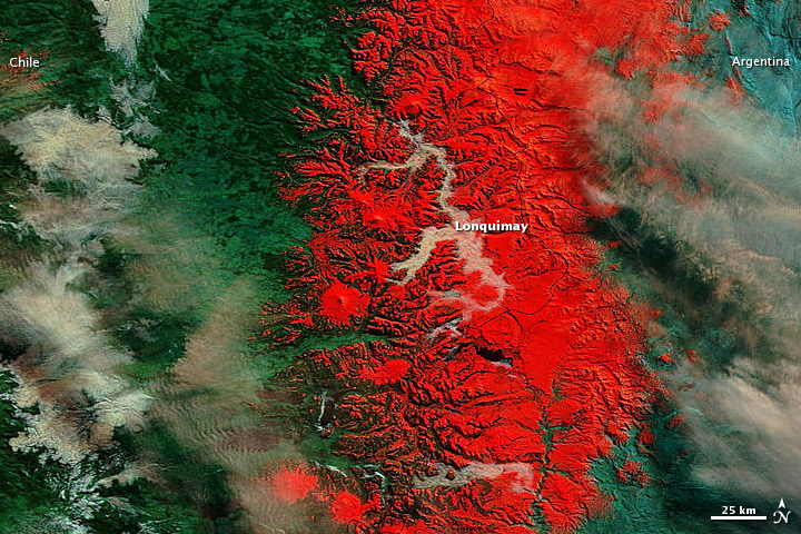
The Moderate Resolution Imaging Spectroradiometer (MODIS) on NASA’s Terra satellite captured images of the region around Lonquimay on July 22, 2011 (shown image), and July 8, 2011.

Using visible and infrared light, these images better distinguish between snow and clouds than a natural-color image would. Snow and ice are bright red or red-orange. Clouds range in color from off-white to peach. Vegetation is green.

Both images show winter conditions but, compared to the image from July 8, the scene from July 22 shows snow blanketing a significantly larger area around Lonquimay. On July 22, fog fills multiple valleys in between the snow-capped peaks.

The Araucanía region in central Chile included some of the hardest hit areas, CNN reported. The government sent food-laden trucks and military helicopters to the region’s remote areas, in hopes of reaching residents stranded by snow-packed roads. Meanwhile, Santiago Times said that frigid temperatures froze pipes, leaving most Lonquimay residents without water.

The heavy snow that buried the region around Lonquimay fell just weeks after rare snow covered parts of Chile’s Atacama Desert.

NASA Earth Observatory
Tue, 26 Jul 2011 - 11:31
Chile

Footer menu

  • Contact
  • Terms of Use

User account menu

  • Log in