Tropical Depression 06W is still slowing, making its way through the South China Sea today and has weakened overnight. NASA infrared satellite imagery showed a much more disorganized storm with scattered convection, which accounts for its weakened status from tropical storm to tropical depression.
On June 21 at 1500 UTC (11 a.m. EDT) the newly weakened Tropical Depression 06W was located about 480 nautical miles east-southeast of Hanoi, Vietnam near 18.8 North and 113.8 East. Depression 06W's maximum sustained winds had decreased to 25 knots (28 mph/46 kmh). It was moving west-southwest at 9 knots (10 mph/17 kmh) and kicking up 11 foot-high waves in the South China Sea.
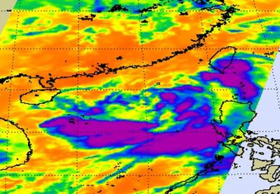
NASA's Atmospheric Infrared Sounder (AIRS) instrument that flies on the Aqua satellite captured an infrared image of 06W on June 20 at 18:05 UTC (2:05 p.m. EDT) when it was still a tropical storm. Since then, convection has become more scattered and winds have lessened. In addition, the low level center of the storm's circulation has become elongated due to wind shear. Elongation of a tropical cyclone is a sign of weakening.
Because of that wind shear, 06W is expected to barely maintain tropical depression strength before it makes landfall on Thursday, June 23 near Jhan Jiang, China. The AIRS infrared image captures cloud top temperatures and the coldest temperatures appeared south of the center of circulation. Those cold cloud top temperatures represented the strongest thunderstorms in the tropical storm where rainfall rates could reach up to 2 inches / 50 mm per hour. Because Tropical Depression 06W has begun moving to the west-southwest, the Joint Typhoon Warning Center has changed the forecast track and taken the depression farther south. The current landfall takes 06W just north of Hainan Island, China and then onto the mainland at the southwestern end of Guangdong province of Southern China.