• English
  • Español
  • Français

United
Nations


Office for Outer Space Affairs
UN-SPIDER Knowledge Portal

  • Home
  • About Us
    • What is UN-SPIDER?
    • About UNOOSA
    • Publications
    • Jobs
    • Meet the Team
    • Contact
  • Space Application
    • Satellite Technology
    • Emergency Mechanisms
    • Recovery Mechanisms
    • International Asteroid Warning Network
    • Space Mission Planning Advisory Group
    • International Space Weather Initiative
    • Space Technologies in the UN
    • User Stories
  • Links & Resources
    • Data Applications
      • Disaster Recovery
    • Data Sources
    • GIS and Remote Sensing Software
    • Online Learning Resources
    • Institutions
  • Risks & Disasters
    • Disaster Risk Management
    • Early Warning Systems
    • Emergency and Disaster Management
    • Natural Hazards
    • Sendai Framework
    • The UN and Disaster Risk Management
    • The UN and Early Warning
    • The UN and Disaster Management
  • Advisory Support
    • Advisory Missions
    • Emergency Support
    • Virtual Advisory Support
    • Recommended Practices
    • Training Activities
    • Practical Uses
  • Network
    • Regional Support Offices
    • GP-STAR
    • MHEWS
    • IWG-SEM
  • Projects
    • SPEAR
    • SEWS-D
    • EvIDENz
    • Flood GUIDE
  • News & Events
    • News
    • Events Calendar
    • UN-SPIDER Events Archive
  • Admin
    • SAM Items

Breadcrumb

  • Home
  • News and Events
  • View Active News
  • International Charter Activated For Hurricane Joaquin In Bahamas
  • International Charter activated for Hurricane Joaquin in Bahamas

International Charter activated for Hurricane Joaquin in Bahamas

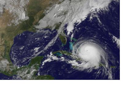
Satellite image of Hurricane Joaquin, taken by GOES East satellite on 1 October. (Source: AFP/NOAA)Satellite image of Hurricane Joaquin, taken by GOES East satellite on 1 October. (Source: AFP/NOAA)

The International Charter: Space and Major Disasters has been triggered to provide satellite-based emergency maps in response to a category four storm that passed over the Bahamas on 2nd. October, causing widespread destruction. Winds of over 130 mph, up to 600mm of rain and 3 metre storm surges have been reported.

The mechanism was activated on 6 October 2015, at 13:01:16 (UTC -05:00) by USGS on behalf of Bahamas Environment. The slow moving storm was said to strengthen further as it moved to the central Bahamas. Locals reported battered trees and buildings without roofs; surging waters also reached the windows of some homes.


The International Charter reported: “The storm path forecasted to travel to states along the eastern US coast. The governors of New Jersey, Virginia, Maryland and North and South Carolina have declared states of emergency. By the 6th October Hurricane Joaquin swept through South Carolina. Heavy rains, around 5-9 inches, fell in 24 hours closing local government offices and schools. Meteorologists forecasted further flash flood warnings before the storm faded, making it unlikely floodwaters would recede quickly.”
International Charter Space & Major Disasters
Wed, 7 Oct 2015 - 15:33

Footer menu

  • Contact
  • Terms of Use

User account menu

  • Log in