
The Japan Aerospace Exploration Agency (JAXA) successfully launched the Advanced Land Observing Satellite-4 “DAICHI-4” (ALOS-4) on 1 July 2024 aboard the third H3 Launch Vehicle (H3 F3) from the Tanegashima Space Center. This new satellite is set to play a crucial role in disaster management and environmental monitoring.
Enhancing Disaster Management Capabilities
ALOS-4 is equipped with a state-of-the-art Phased Array type L-band Synthetic Aperture Radar-3 (PALSAR-3) and the SPace-based AIS Experiment (SPAISE3). These advanced instruments enable the satellite to conduct high-resolution, broad-swath observations regardless of time of day or weather conditions. This makes ALOS-4 an invaluable asset for disaster monitoring and management.
Key Features and Applications:
- Continuous Monitoring: Unlike optical sensors, radar technology enables ALOS-4 to capture images day and night and through cloud cover. This capability ensures uninterrupted monitoring of disaster-hit areas, providing critical real-time data to response teams.
- High-Frequency Observations: ALOS-4 will increase observation frequency from four times a year to once every two weeks for active volcanoes in Japan. This frequent monitoring allows for early detection of abnormal changes, such as unusual volcanic activity, land subsidence, or landslides, providing timely warnings to potentially affected populations.
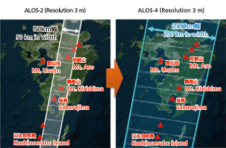
- Broad-Swath Coverage: The observation swath has been significantly expanded from 50 km to 200 km while maintaining high resolution. This enhancement allows ALOS-4 to monitor larger areas simultaneously, which is particularly beneficial during large-scale disasters like major earthquakes or multiple volcanic eruptions.
- Ground Deformation Monitoring: The radar satellite can measure ground displacement caused by volcanic activity or earthquakes to within a few centimeters. Continuous monitoring of volcanoes can help estimate magma reservoir locations and movements, contributing to a better understanding of volcanic activities.
Operational Phase and Future Prospects
Having completed the critical operations phase, which included deploying solar array paddles and mission payload antennas, ALOS-4 will now enter the initial functional verification operations phase. Over the next three months, JAXA and its partners will verify the functions of the onboard instruments.
The successful deployment and operation of ALOS-4 marks a significant milestone in JAXA’s mission to enhance disaster management and environmental monitoring capabilities. The satellite’s advanced technology promises to provide comprehensive and timely data, improving disaster response efforts and contributing to the safety and preparedness of communities worldwide.
For further details, please visit the JAXA website.
Note: This article is based on official statements and data provided by JAXA regarding the launch and operational status of the ALOS-4 satellite.
Images: Provided by Japan Aerospace Exploration Agency (JAXA)