Working in close collaboration with the US Department of the Interior (DOI), Esri is pleased to announce the release of Landsat image services. These provide access to almost four decades' worth of Global Land Survey (GLS) Landsat data developed by the National Aeronautics and Space Administration (NASA) and DOI's US Geological Survey. Esri provides access to the full multispectral, multitemporal Landsat data for free on ArcGIS Online as dynamic image services.
"These Landsat image services expand the ability to monitor landscape change to Internet users worldwide," says Jack Dangermond, president of Esri. "We're excited to showcase this valuable government resource that uses ArcGIS to rapidly deliver Landsat data so that it can be used to help users understand changes in the world."
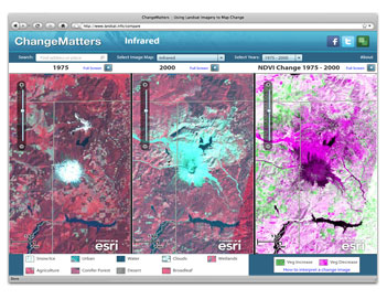
Esri has also published an interactive website that leverages these Landsat image services to provide a starting point for understanding earth changes over time.
"The Esri Landsat services suite will enable users to access satellite images of the earth and see through time what’s happened to our globe," stated Deputy Secretary of the Interior David J. Hayes. "Whether you’re a fourth grader or in the midst of writing your PhD thesis, having the ability to go back 30 years and visualise multitemporal earth imagery can be tremendously helpful in answering questions about how we should manage the planet and address real-world problems.”
The Landsat image services from Esri leverage the 40-year, multibillion-dollar US government investment in the collection and archiving of continuous worldwide Landsat imagery for earth observation. At 30-metre spatial resolution, Landsat imagery is excellent for mapping regional trends in climate change, agriculture, wildlife habitat, forestry, regional planning, coastal zones, and national security. Each Landsat satellite image also "sees" more than humans by collecting data in nonvisible wavelengths such as the infrared and optical (natural color) portions of the electromagnetic spectrum.