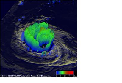
NASA's TRMM satellite passed over the hurricanes that are passing over the Eastern Pacific Ocean: Emilia and Daniel. In pinpointed the intensity of the rainfall within each storm, the data reveals their power. Emilia is dropping rain at a greater rate than Daniel according to satellite data. TRMM flew above hurricane Daniel on July 8, 2012 at 0019 UTC and over Emilia when it was a tropical storm on July 8, 2012 at 0837 UTC. Rainfall data collected with TRMM's Microwave Imager (TMI) and Precipitation Radar (PR) instruments was overlaid on enhanced infrared and visible images from TRMM's Visible and InfraRed Scanner (VIRS) at NASA's Goddard Space Flight Center in Greenbelt, Md. to show the intensity of the rain falling within each storm.
NASA's Terra satellite also passed over both storms, providing a clear, visible image of the cloud cover and extent on July 8. At that time, compact Daniel had a visible eye, while Emilia did not, and was still getting organized. Emilia is expected to become a major hurricane in the next days, while Daniel weakens.

