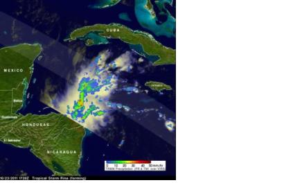
NASA's Tropical Rainfall Measuring Mission satellite called "TRMM" and NASA's Aqua satellite captured radar and temperature data that showed Tropical Storm Rina forming in the western Caribbean Sea yesterday. Today, Rina continues strengthening.
The National Hurricane Center (NHC) upgraded an area of disturbed weather in the Caribbean to tropical depression eighteen and then to tropical storm Rina on October 23, 2011. The TRMM satellite flew over the forming tropical cyclone on October 23, 2011 at 1728 UTC (1:28 p.m. EDT).
Data from TRMM's Microwave Imager (TMI) and Precipitation Radar (PR) was used to create a rainfall image from the TRMM team at NASA's Goddard Space Flight Center in Greenbelt, Md. The rainfall image showed that the future storm already was well organized and had a large area of heavy rainfall extending toward the northeast from eastern Honduras. Up until the morning hours (local time) on Monday, October 24, Honduras had a tropical storm watch in effect for its northeastern coast. That watch was dropped by 10 a.m. EDT as Rina moved away.
Today, Oct. 24, that rainfall is affecting the northeastern coast of Honduras and Cayman Islands. The NHC said "Rina is expected to produce total rain accumulations of 1 to 3 inches along the northeast coast of Honduras. Rainfall amounts of 2 to 4 inches are possible over the Cayman Islands."
At 11 a.m. EDT on Oct. 24, Rina's maximum sustained winds were near 45 mph (75 kmh). Those tropical storm-force winds extend out 85 miles (140 km) from the center, making Rina a small tropical storm over 170 miles in diameter.
Rina is in an environment with warm water (over the 80F/26.6C threshold needed to maintain a tropical cyclone) and low wind shear. It is centered near 17.1 North latitude and 82.9 West longitude, which is about 190 miles (305 km) southwest of Grand Cayman and 370 miles (595 km) east-southeast of Chetumal, Mexico. Rina was moving to the northwest at 6 mph (9 kmh). Minimum central pressure is 1001 millibars.
When NASA's Aqua satellite passed over Rina earlier today at 2:47 a.m. EDT the Atmospheric Infrared Sounder (AIRS) instrument took an infrared reading of Rina's cloud top temperatures. The colder the cloud top temperatures, the higher and stronger they are. AIRS temperature data showed a very large area of strong convection and thunderstorms around the center of circulation where cloud top temperatures were colder than -63F (-52C). Those temperatures indicate strong thunderstorms and heavy rainfall. AIRS infrared data showed that Rina continues to become better organized. The AIRS data was created into a color-coded image at NASA's Jet Propulsion Laboratory in Pasadena, Calif.
There are a couple of factors steering Rina through the Caribbean Sea. In the mid-level of the atmosphere there's a ridge (elongated area) of high pressure building over the northern Gulf of Mexico, which is expected to turn Rina to the west-northwest. The NHC noted that as the ridge moves eastward in a couple of days, it will take Rina northwest, then northward. The NHC expects Rina to become a hurricane tomorrow

