• English
  • Español
  • Français

United
Nations


Office for Outer Space Affairs
UN-SPIDER Knowledge Portal

  • Home
  • About Us
    • What is UN-SPIDER?
    • About UNOOSA
    • Publications
    • Jobs
    • Meet the Team
    • Contact
  • Space Application
    • Satellite Technology
    • Emergency Mechanisms
    • Recovery Mechanisms
    • International Asteroid Warning Network
    • Space Mission Planning Advisory Group
    • International Space Weather Initiative
    • Space Technologies in the UN
    • User Stories
  • Links & Resources
    • Data Applications
      • Disaster Recovery
    • Data Sources
    • GIS and Remote Sensing Software
    • Online Learning Resources
    • Institutions
  • Risks & Disasters
    • Disaster Risk Management
    • Early Warning Systems
    • Emergency and Disaster Management
    • Natural Hazards
    • Sendai Framework
    • The UN and Disaster Risk Management
    • The UN and Early Warning
    • The UN and Disaster Management
  • Advisory Support
    • Advisory Missions
    • Emergency Support
    • Virtual Advisory Support
    • Recommended Practices
    • Training Activities
    • Practical Uses
  • Network
    • Regional Support Offices
    • GP-STAR
    • MHEWS
    • IWG-SEM
  • Projects
    • SPEAR
    • SEWS-D
    • EvIDENz
    • Flood GUIDE
  • News & Events
    • News
    • Events Calendar
    • UN-SPIDER Events Archive

Breadcrumb

  • Home
  • News and Events
  • View Active News
  • NASA To Launch SMAP Satellite To Combat Drought
  • NASA to Launch SMAP Satellite to Combat Drought

NASA to Launch SMAP Satellite to Combat Drought

Soil Moister Active Passive SatelliteSMAP Satellite

At present no ground or satellite based global network infrastructure exists for monitoring soil moisture on a local level. The Soil Moisture Active Passive SMAP satellite mission to be launched in October 2014 as part of NASA’s fall launch schedule will collect local data agriculture and water managers needed globally.  SMAP’s payload includes two microwave instruments capable of monitoring Earth’s surface to a depth of 5 cm mapping the planet every two to three days. Providing the most detailed soils maps to date in an effort to fill the infrastructure gap.

"Scientists see tremendous potential in SMAP. It is not going to provide field-level information, but it will give very useful new regional observations of soil moisture conditions, which will be important for drought monitoring and a wide range of applications related to agriculture. Having the ability provided by SMAP to continuously map soil moisture conditions over large areas will be a major advance", said Forrest Melton, a research scientist in the Ecological Forecasting Lab at NASA Ames Research Center. 
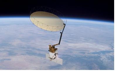
NASA
Wed, 20 Aug 2014 - 14:24

Footer menu

  • Contact
  • Terms of Use

User account menu

  • Log in