• English
  • Español
  • Français

United
Nations


Office for Outer Space Affairs
UN-SPIDER Knowledge Portal

  • Home
  • About Us
    • What is UN-SPIDER?
    • About UNOOSA
    • Publications
    • Jobs
    • Meet the Team
    • Contact
  • Space Application
    • Satellite Technology
    • Emergency Mechanisms
    • Recovery Mechanisms
    • International Asteroid Warning Network
    • Space Mission Planning Advisory Group
    • International Space Weather Initiative
    • Space Technologies in the UN
    • User Stories
  • Links & Resources
    • Data Applications
      • Disaster Recovery
    • Data Sources
    • GIS and Remote Sensing Software
    • Online Learning Resources
    • Institutions
  • Risks & Disasters
    • Disaster Risk Management
    • Early Warning Systems
    • Emergency and Disaster Management
    • Natural Hazards
    • Sendai Framework
    • The UN and Disaster Risk Management
    • The UN and Early Warning
    • The UN and Disaster Management
  • Advisory Support
    • Advisory Missions
    • Emergency Support
    • Virtual Advisory Support
    • Recommended Practices
    • Training Activities
    • Practical Uses
  • Network
    • Regional Support Offices
    • GP-STAR
    • MHEWS
    • IWG-SEM
  • Projects
    • SPEAR
    • SEWS-D
    • EvIDENz
    • Flood GUIDE
  • News & Events
    • News
    • Events Calendar
    • UN-SPIDER Events Archive

Breadcrumb

  • Home
  • News and Events
  • View Active News
  • NASA Satellites Capture California Wildfires
  • NASA satellites capture California wildfires

NASA satellites capture California wildfires

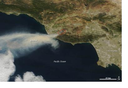
The red lines indicate areas where MODIS detected fires.The red lines indicate areas where MODIS detected fires.

In early May 20103, dry Santa Ana winds started several wildfires in Southern California, USA. NASA's Terra and Aqua satellites captured images of the fires with their Moderate Resolution Imaging Spectroradiometer (MODIS). The red lines on the picture indicate where MODIS detected unusually warm surface temperatures indicating fires about 50 miles north of Los Angeles.

NASA reported: "According to firefighting agencies in California, the Springs fire had spread over 10,000 acres by 6:30 a.m. on May 3. More than 30 homes and other buildings had been damaged by fire, and another 4,300 were threatened. The fire was being fought by more than 900 firefighters on the ground and 14 water-dropping helicopters and planes, and it was 10 percent contained by the morning of May 3.
NASA
Mon, 6 May 2013 - 10:56

Footer menu

  • Contact
  • Terms of Use

User account menu

  • Log in