NASA's Terra satellite saw the western edges of Typhoon Nesat brushing the eastern Philippines yesterday as Luzon prepares for a landfall today. Warning Signals are in effect throughout the northern Philippines as the typhoon nears.
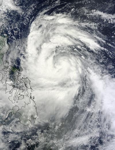
NASA's Terra satellite flew over Typhoon Nesat yesterday. Nesat is known locally in the Philippines as "Pedring." NASA's Moderate Resolution Imaging Spectroradiometer (MODIS) captured a visible image of the large storm on Sunday, Sept. 25 at 2:40 UTC (10:40 a.m. local time/Philippines) as its western edges began to spread over the Philippines. Although the visible image did not reveal an eye because it was cloud-filled, satellite microwave imagery did spot the eye.
Typhoon Nesat has maximum sustained winds near 80 knots (92 mph/148 kmh) on Monday, Sept. 26 as its center approaches northern Luzon, Philippines. It was located only 225 miles east-northwest of Manila, near 15.9 North and 124.2 East. It was moving to the west-northwest near 14 knots (16 mph/26 kmh).
Satellite imagery shows tightly-curved bands of thunderstorms wrapping into the low level center of circulation. That's an indication the storm is well-organized. The strongest convection and thunderstorms are mostly over the western semi-circle of the storm today. Microwave satellite data does reveal Nesat has an eye which helps forecasters pinpoint Nesat's center.
PAGASA, the Philippines' meteorological service expects Nesat (Pedring) will make landfall Tuesday afternoon (local time/Philippines) over Casiguran, Aurora and will be in the vicinity of Baguio City. Coastal areas can expect dangerous surf and high ocean swells, heavy rainfall and gusty winds.
Many watches and warnings are in effect. A Signal 3 (for the strongest winds) has been posted for: Catanduanes, Camarines Sur, Camarines Norte, Northern Quezon, Polillo Island, Aurora, Quirino and Isabela. Signal 2 is in effect for Albay, Burias Island, Sorsogon, Rest of Quezon, Rizal, Bulacan, Nueva Ecija, Nueva Vizcaya, Ifugao, Benguet, Mt. Province, Kalinga, Cagayan and Metro Manila. Signal 1 has been raised for Ticao Island, Masbate, Marinduque, Batangas, Cavite, Bataan, Laguna, Pampanga, Zambales, Tarlac, Pangasinan, La Union, Ilocos Sur, Ilocos Norte, Abra, Apayao, Calayan, and the Babuyan Group of Islands.
The Joint Typhoon Warning Center forecasts Nesat to continue tracking due west over Luzon and make landfall with maximum sustained winds near 90 knots (103 mph/166 kmh). It is forecast to cross Luzon and move into the South China Sea in one day.