• English
  • Español
  • Français

United
Nations


Office for Outer Space Affairs
UN-SPIDER Knowledge Portal

  • Home
  • About Us
    • What is UN-SPIDER?
    • About UNOOSA
    • Publications
    • Jobs
    • Meet the Team
    • Contact
  • Space Application
    • Satellite Technology
    • Emergency Mechanisms
    • Recovery Mechanisms
    • International Asteroid Warning Network
    • Space Mission Planning Advisory Group
    • International Space Weather Initiative
    • Space Technologies in the UN
    • User Stories
  • Links & Resources
    • Data Applications
      • Disaster Recovery
    • Data Sources
    • GIS and Remote Sensing Software
    • Online Learning Resources
    • Institutions
  • Risks & Disasters
    • Disaster Risk Management
    • Early Warning Systems
    • Emergency and Disaster Management
    • Natural Hazards
    • Sendai Framework
    • The UN and Disaster Risk Management
    • The UN and Early Warning
    • The UN and Disaster Management
  • Advisory Support
    • Advisory Missions
    • Emergency Support
    • Virtual Advisory Support
    • Recommended Practices
    • Training Activities
    • Practical Uses
  • Network
    • Regional Support Offices
    • GP-STAR
    • MHEWS
    • IWG-SEM
  • Projects
    • SPEAR
    • SEWS-D
    • EvIDENz
    • Flood GUIDE
  • News & Events
    • News
    • Events Calendar
    • UN-SPIDER Events Archive
  • Admin
    • SAM Items

Breadcrumb

  • Home
  • News and Events
  • View Active News
  • NASA's Aqua Satellite Tracks Tropical Storm Flossie
  • NASA's Aqua satellite tracks Tropical Storm Flossie

NASA's Aqua satellite tracks Tropical Storm Flossie

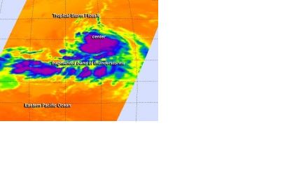
Flossie is moving toward the westThe AIRS instrument aboard NASA's Aqua satellite captured this infrared image of Tropical Storm Flossie on July 25

The Atmospheric Infrared Sounder or AIRS mechanism aboard the NASA's Aqua satellite captured infrared images of Tropical Storm Flossie on July 25 2013, providing helpful data such as the temperature, the strongest storms and the heaviest rains within Flossie. On the basis of the available information, the National Hurricane Center, or NHC, expects that Flossie will keep moving toward the west for the next couple of days as it has been doing until now. Nevertheless, NHC also anticipates some strengthening of Flossie's winds during the next 48 hours.

What we see on the picture is one of the previously mentioned infrared images, where the AIRS revealed that the strongest storms and heaviest rains of the Tropical Storm Flossie were around its center and in a fragmented band of thunderstorms south of the center, with cloud top temperatures near -63F/-52C by July 25 (represented in purple).
NASA
Fri, 26 Jul 2013 - 13:14

Footer menu

  • Contact
  • Terms of Use

User account menu

  • Log in