• English
  • Español
  • Français

United
Nations


Office for Outer Space Affairs
UN-SPIDER Knowledge Portal

  • Home
  • About Us
    • What is UN-SPIDER?
    • About UNOOSA
    • Publications
    • Jobs
    • Meet the Team
    • Contact
  • Space Application
    • Satellite Technology
    • Emergency Mechanisms
    • Recovery Mechanisms
    • International Asteroid Warning Network
    • Space Mission Planning Advisory Group
    • International Space Weather Initiative
    • Space Technologies in the UN
    • User Stories
  • Links & Resources
    • Data Applications
      • Disaster Recovery
    • Data Sources
    • GIS and Remote Sensing Software
    • Online Learning Resources
    • Institutions
  • Risks & Disasters
    • Disaster Risk Management
    • Early Warning Systems
    • Emergency and Disaster Management
    • Natural Hazards
    • Sendai Framework
    • The UN and Disaster Risk Management
    • The UN and Early Warning
    • The UN and Disaster Management
  • Advisory Support
    • Advisory Missions
    • Emergency Support
    • Virtual Advisory Support
    • Recommended Practices
    • Training Activities
    • Practical Uses
  • Network
    • Regional Support Offices
    • GP-STAR
    • MHEWS
    • IWG-SEM
  • Projects
    • SPEAR
    • SEWS-D
    • EvIDENz
    • Flood GUIDE
  • News & Events
    • News
    • Events Calendar
    • UN-SPIDER Events Archive

Breadcrumb

  • Home
  • News and Events
  • View Active News
  • New Tools To Enhance Storm Prediction In The Gulf of Mexico
  • New tools to enhance storm prediction in the Gulf of Mexico

New tools to enhance storm prediction in the Gulf of Mexico

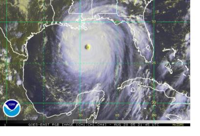
With the new GPS-based tools more precise storm prediction is possible for the Gulf of Mexico (Image: NOAA)With the new GPS-based tools more precise storm prediction is possible for the Gulf of Mexico (Image: NOAA)

The foundation of the Gulf of Mexico Coastal Ocean Observing System (GCOOS) has provided new tools helping to predict storms and enhance ship navigation. Texas, Louisiana, Mississippi, Alabama and Florida will be covered with more accurate information thanks to the GPS Continually Operating Reference Systems (CORS) and Physical Oceanographic Real-Time System (PORTS®) tools that are being implemented through local, state and federal partnerships.

The new CORS provide location data at centimeter-level accuracy, which allows improving the accuracy of coastal mapping, surveying and restoration and flood protection as well as developing better coastal models for hurricanes and flooding.

"This system will help local and regional leaders plan for improved resilience to any impacts of sea level rise or subsidence and coastal storm surge flooding. The project will assist development of long-term strategies to address coastal change impacts along the northern Gulf of Mexico," said Dr. Gary Jeffress, director of the Conrad Blucher Institute for Surveying and Science, part of the Gulf Coast Spatial Reference Consortium, which has contributed to the project.
Sensors&Systems
Wed, 17 Jun 2015 - 08:33
United States of America

Footer menu

  • Contact
  • Terms of Use

User account menu

  • Log in