
The WARM project by Marple GmbH demonstrates how freely available satellite data and machine learning can track flood, drought, and pollution events in real time, with implications for water managers and disaster risk authorities worldwide.
Access to timely, reliable information on river water quantity and quality is a persistent challenge for disaster risk management agencies; particularly in remote regions and areas affected by cloud cover. A new user story published on the UN-SPIDER Knowledge Portal describes how the WARM (Water Stress Monitoring) project, developed by German start-up Marple GmbH, is addressing this gap using satellite Earth Observation and artificial intelligence.
WARM was piloted on two rivers of strategic importance identified in the water mandate list: the Guadalquivir River in southern Spain and the Tana River in south-eastern Kenya. Together, these two case studies illustrate the system's ability to respond to very different hydrological and operational challenges.
What WARM does
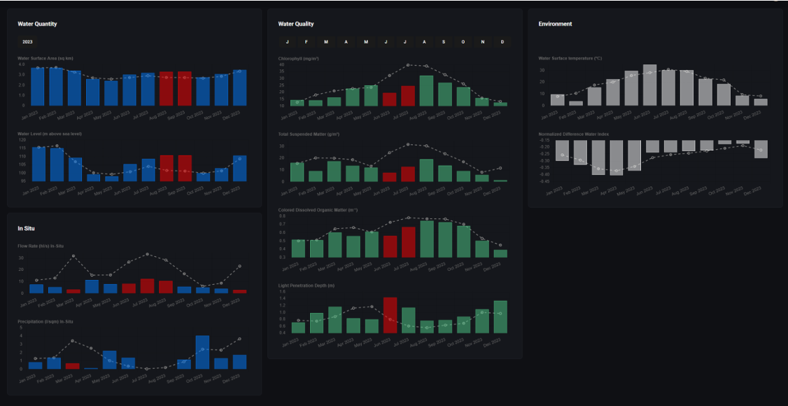
The platform integrates data from the ESA's freely available Sentinel-1 (radar/SAR) and Sentinel-2 (optical) constellations to deliver two core capabilities: water quantity assessment, including surface water extent and estimated water levels; and water quality monitoring, classifying pollution levels using the internationally recognised Trophic State Index.
Key capabilities
- Water quantity: Surface water extent and level estimation derived entirely from satellite data, requiring no ground-based gauging stations.
- Water quality: Chlorophyll-a concentration, total suspended matter, dissolved organic carbon, and water clarity assessed via AI-powered analysis of satellite imagery.
- Cloud-independent monitoring: Sentinel-1 radar fills observational gaps during cloudy seasons; critical for regions like the Tana Basin in Kenya.
Two rivers, two challenges
In Córdoba, Spain, WARM's water quality module was tested against a real pollution event. In May 2021, sewage and wastewater accumulated near the historic city's Molino de Martos area, prompting residents to contact UNESCO (El Día de Córdoba, 2021). Satellite analysis captured the trophic state of the Guadalquivir shifting toward eutrophic and supereutrophic conditions as pollution spread and retreating as conditions improved; providing authorities with spatially precise, satellite-verified evidence beyond anecdotal reports.
On the Tana River in Kenya, the challenge is one of scale and cloud cover. The river supplies 95% of Nairobi's water and generates half of Kenya's hydropower, yet persistent cloud cover during flood season renders optical satellite imagery unreliable (Water Resources Authority). WARM's Sentinel-1 SAR integration delivers cloud-independent flood inundation mapping year-round, supporting Kenyan water authorities with consistent monitoring regardless of weather conditions.
A replicable, low-cost model
Because WARM is built on freely available Copernicus satellite data and modular, reproducible workflows, the approach can be adapted and deployed by national agencies and regional support offices at low cost. The accompanying monitoring application translates satellite outputs into yearly trend charts, seasonal pattern analysis, and anomaly detection tools designed for decision-makers who are not remote sensing specialists.