La Nina and Warm Ocean Temperatures Drive Increased Tropical Activity
Forecasters of the National Oceanic and Atmospheric Administration of the United States (NOAA) at the Climate Prediction Center anticipate an above-normal hurricane season in the Atlantic basin for 2024. The season, spanning from June 1 to November 30, holds an 85% likelihood of above-normal activity, with predictions suggesting 17 to 25 named storms. Among these, 8 to 13 are expected to become hurricanes, including 4 to 7 major hurricanes of Category 3 or higher.
Several climatic factors contribute to this heightened activity. Near-record warm ocean temperatures in the Atlantic, the development of La Nina conditions in the Pacific, reduced Atlantic trade winds, and decreased wind shear are all conducive to storm formation and intensification.
As one of the strongest El Ninos on record transitions to La Nina, conditions favoring Atlantic hurricane activity are expected. La Nina typically reduces wind shear in the tropics, while abundant oceanic heat content in the Atlantic and Caribbean fuels storm development. Additionally, the potential for an above-normal west African monsoon could contribute to strong and long-lasting storms. Human-caused climate change is exacerbating these factors by warming oceans and raising sea levels, which increase storm surge risk.
Enhanced Forecast Communications and New Tools
NOAA will roll out several improvements for the 2024 season:
- The National Hurricane Center (NHC) will expand Spanish language text products and introduce an experimental forecast cone graphic depicting inland storm warnings.
- U.S. tropical cyclone watches and warnings can now be issued with regular or intermediate public advisories, enhancing the timeliness of updates.
- New forecast models, including the Modular Ocean Model (MOM6) and SDCON, will improve hurricane intensity predictions and the probability of rapid intensification.
Earth Observation Technologies Bolster Forecasting Efforts
NOAA’s enhanced observing systems and technologies are critical for hurricane forecasting and monitoring:
- Upgraded coastal weather buoys and new Directional Wave Spectra Drifters will provide real-time data on ocean and atmospheric conditions.
- Observational underwater gliders and Streamsondes will gather valuable wind data during storm development.
- The CHAOS research experiment will improve understanding of air-sea interactions.
NOAA’s advanced technologies and comprehensive seasonal outlooks support early warning efforts, enabling communities to better prepare and respond to hurricanes. The Climate Prediction Center will update the 2024 Atlantic seasonal outlook in early August, ahead of the season’s peak.
Find more information in the original article on the NOAA website.
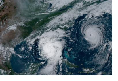
Article image: NOAA's GOES-16 satellite captured Hurricane Idalia approaching the western coast of Florida while Hurricane Franklin churned in the Atlantic Ocean at 5:01 p.m. EDT on August 29, 2023.

