• English
  • Español
  • Français

United
Nations


Office for Outer Space Affairs
UN-SPIDER Knowledge Portal

  • Home
  • About Us
    • What is UN-SPIDER?
    • About UNOOSA
    • Publications
    • Jobs
    • Meet the Team
    • Contact
  • Space Application
    • Satellite Technology
    • Emergency Mechanisms
    • Recovery Mechanisms
    • International Asteroid Warning Network
    • Space Mission Planning Advisory Group
    • International Space Weather Initiative
    • Space Technologies in the UN
    • User Stories
  • Links & Resources
    • Data Applications
      • Disaster Recovery
    • Data Sources
    • GIS and Remote Sensing Software
    • Online Learning Resources
    • Institutions
  • Risks & Disasters
    • Disaster Risk Management
    • Early Warning Systems
    • Emergency and Disaster Management
    • Natural Hazards
    • Sendai Framework
    • The UN and Disaster Risk Management
    • The UN and Early Warning
    • The UN and Disaster Management
  • Advisory Support
    • Advisory Missions
    • Emergency Support
    • Virtual Advisory Support
    • Recommended Practices
    • Training Activities
    • Practical Uses
  • Network
    • Regional Support Offices
    • GP-STAR
    • MHEWS
    • IWG-SEM
  • Projects
    • SPEAR
    • SEWS-D
    • EvIDENz
    • Flood GUIDE
  • News & Events
    • News
    • Events Calendar
    • UN-SPIDER Events Archive

Breadcrumb

  • Home
  • News and Events
  • View Active News
  • RADARSAT-2 Data Helps Manage Canadian Richelieu River Flood
  • RADARSAT-2 Data helps manage Canadian Richelieu River Flood

RADARSAT-2 Data helps manage Canadian Richelieu River Flood

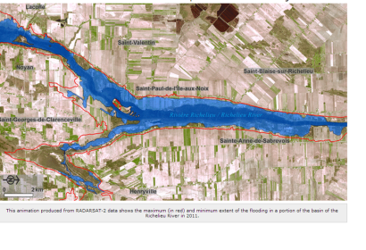
Animation of the Richelieu floods using RADARSAT-2 data.

Within the framework of the international Committee on Satellite Earth Observation (CEOS), the Canadian Space Agency (CSA) is collaborating with NASA on various projects helping to prevent, manage and respond to natural disasters. During the spring flood along the Richelieu River in May 2011, CSA asked colleagues from NASA to acquire satellite images with the EO-1/ALI sensor in order to capture the flood extent. The ALI images complement an entire time series of RADARSAT-2 images acquired by the Canadian Government over the affected region, providing additional details thanks to the multi-spectral and pan-chromatic imaging capabilities of ALI.

Through the new Rapid Information Products and Services (RIPS) initiative, the CSA’s Earth Observation Applications and Utilizations (EOAU) Division, in close cooperation with Public Safety Canada (PS) and Effigis, developed flood maps and geo-information products derived from the RADARSAT-2 and EO-1/ALI data. A time series animation of 16 RADARSAT-2 SAR images of the most severely flooded areas along the Richelieu River was also developed by the project team. This information serves geospatial information needs and requirements by federal as well as provincial stakeholder organizations, notably PS, the Sécurité Civile du Québec and Québec municipalities. The animation produced from RADARSAT-2 data showing the maximum and minimum extent of the flooding is accessible online.

Emergency Management is a core responsibility of the Government of Canada and a collective responsibility of all federal government institutions. This is why PS is taking steps to promote a coordinated approach and more uniform structure to the management of emergencies by providing guidance to federal government institutions on how to develop an emergency management plan.
Effigis (pdf-document)
Mon, 15 Oct 2012 - 09:04
Canada

Footer menu

  • Contact
  • Terms of Use

User account menu

  • Log in