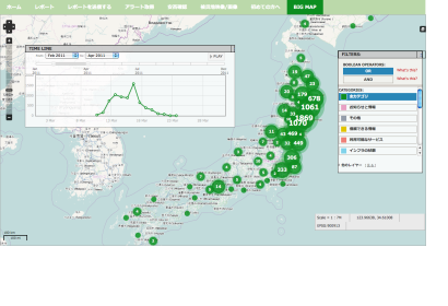
After the Great Earthquake hit Japan exactly two years ago, the importance of crowdsourced crisis mapping in any kind of disaster became evident once again. The recently released study "Connecting the Last Mile: Internews Europe Report on the Role of Communications in the Great East Japan Earthquake" elaborated by the UK NGO Internews Europe highlights how communication saved lives after the Japan earthquake and tsunami and how it was essential in helping survivors in the days, weeks and months to recover from the triple earthquake, tsunami and nuclear power crisis.
In the chapter "Technology volunteers: Crisis Mapping the Disaster", the report sheds light on Japan’s version of the Ushahidi crisis map, sinsai.info, meaning “disaster info”, that had been created only hours after the earthquake. It also showcases how Open Street Map (OSM) created a map with 500,000 roads that was shared on the National Research Institute for Earth Science and Disaster Prevention’s website.
The report shows once again how social media in crisis mapping has revolutionized the role of those affected in disasters. For example, Twitter and Facebook play an important role because they provided a platform for individuals to locate and inform their families or friends.
UN-SPIDER strongly pushes for the use of crowdsourced data and maps in crisis situations as well as for disaster risk management. The Newsletter "Getting the bigger picture: Crowdsource Mapping for Disasters" presents UN-SPIDER's efforts in this regard.

