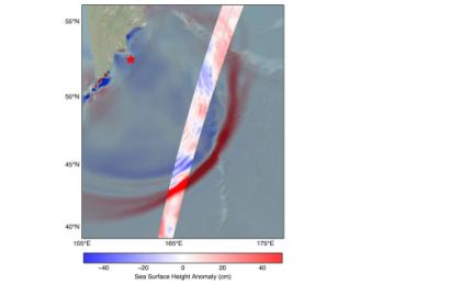
US-French SWOT Satellite Measures Tsunami after 8.8 magnitude earthquake
The Surface Water and Ocean Topography (SWOT) satellite, jointly developed by NASA and the French space agency CNES with contributions from the Canadian Space Agency and the UK Space Agency, is providing valuable data to improve tsunami forecast models and strengthen early warning systems for coastal communities.
On 30 July, SWOT captured data on the tsunami generated by an 8.8 magnitude earthquake off Russia’s Kamchatka Peninsula. About 70 minutes after the quake, the satellite recorded a wave exceeding 45 cm in height and mapped its shape and direction of travel. These measurements were compared with forecast outputs from the U.S. National Oceanic and Atmospheric Administration (NOAA) Center for Tsunami Research, confirming the accuracy of the model and offering new insights to refine it further. Accurate tsunami modelling is essential, as even waves of just a few dozen centimetres in the open ocean can rise dramatically when they reach shallower coastal waters.
SWOT’s unique capabilities, including its Ka-band Radar Interferometer (KaRIn) instrument, enable it to measure the height and movement of surface water across oceans, lakes, and rivers with unprecedented detail. While its primary mission is to map global surface water resources and ocean topography, SWOT’s observations also have critical applications for disaster risk reduction — from monitoring extreme events such as tsunamis to improving flood modelling and coastal resilience planning.
By integrating SWOT’s multidimensional data into their forecasting systems, agencies such as NOAA can enhance their ability to provide timely and accurate tsunami warnings, helping to reduce the risks faced by vulnerable coastal populations.
Read the full story here: US-French SWOT Satellite Measures Tsunami After Massive Quake - NASA
To learn more about SWOT, visit: Home – NASA SWOT

