  • English
  • Español
  • Français

United
Nations


Office for Outer Space Affairs
UN-SPIDER Knowledge Portal

  • Home
  • About Us
    • What is UN-SPIDER?
    • About UNOOSA
    • Publications
    • Jobs
    • Meet the Team
    • Contact
  • Space Application
    • Satellite Technology
    • Emergency Mechanisms
    • Recovery Mechanisms
    • International Asteroid Warning Network
    • Space Mission Planning Advisory Group
    • International Space Weather Initiative
    • Space Technologies in the UN
    • User Stories
  • Links & Resources
    • Data Applications
      • Disaster Recovery
    • Data Sources
    • GIS and Remote Sensing Software
    • Online Learning Resources
    • Institutions
  • Risks & Disasters
    • Disaster Risk Management
    • Early Warning Systems
    • Emergency and Disaster Management
    • Natural Hazards
    • Sendai Framework
    • The UN and Disaster Risk Management
    • The UN and Early Warning
    • The UN and Disaster Management
  • Advisory Support
    • Advisory Missions
    • Emergency Support
    • Virtual Advisory Support
    • Recommended Practices
    • Training Activities
    • Practical Uses
  • Network
    • Regional Support Offices
    • GP-STAR
    • MHEWS
    • IWG-SEM
  • Projects
    • SPEAR
    • SEWS-D
    • EvIDENz
    • Flood GUIDE
  • News & Events
    • News
    • Events Calendar
    • UN-SPIDER Events Archive

Breadcrumb

  • Home
  • News and Events
  • View Active News
  • Satellite Programs Aid Emergency Crews Battling Wildfires
  • Satellite programs aid emergency crews battling wildfires

Satellite programs aid emergency crews battling wildfires

Multiple firefighting agencies are using imagery -- provided by federally funded Landsat 5 and 7, Aqua and Terra satellites -- to combat wildfires that continue to blaze across Arizona.

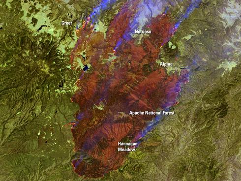
The satellites capture images of the Earth's surface and then, using color enhancements, firefighters can identify different regions most susceptible to wildfire burning. In the images, burn scars are red, ongoing fires are bright red, vegetation is green, smoke is blue and bare ground is tan-colored.

 When the locationBurning in the mountains of eastern Arizona near the border with New Mexico, the Wallow Fire has become the second largest fire in Arizona history.
CAPTIONUSGS of a wildfire is found, emergency managers can evacuate people in the path of the fire and pinpoint where water and firefighters need to go.

"In addition to providing information used to map the susceptibility of the forests to wildfires, the satellites can also provide emergency management agencies with data to gauge the extent of damage that was done over burnt areas," says Jim Irons, Landsat Data Continuity Mission (LDCM) project scientist.

Once a satellite has taken a photograph of the land after the wildfire has been contained, emergency managers can distinguish areas of land that have suffered extensive burning from those that remain intact. From this, officials can work to determine the cause of the wildfire and work towards preventing another one from happening. The Landsat Program, a joint venture between NASA and the U.S. Geological Survey, has recently helped emergency managers survey the damage caused by Hurricane Katrina, Mississippi River flooding, and a tornado that ripped through Springfield, Mass.


USA TODAY
Thu, 23 Jun 2011 - 14:44

Footer menu

  • Contact
  • Terms of Use

User account menu

  • Log in