For more than a decade Earth-observing satellites have been scanning the surface of our planet searching for fires while scientists combine their space-based data to predict crucial fire behavior and therefore try to mitigate potential damages. In the western United States, California and Colorado, the 2013 wildfire season has started earlier than normal due to the favorable conditions for fire present in this area. "Over the last 30 years we have seen an increase in hot and dry conditions that promote fire activity," said Doug Morton, a scientist at NASA's Goddard Space Flight Center, Greenbelt, Md. As a result, by the 8 August 2013, wildfires have burned more than 2.5 million acres in the United States.
In order to prevent potential and unnecessary damages, scientists from NASA, universities and other government agencies are refining their satellite observation and computer modeling capabilities. With this purpose, for more than ten years already NASA's Terra and Aqua satellites have been circling the globe every 99 minutes collecting and providing decisive scientific data through the Moderate Resolution Imaging Spectroradiometer (MODIS). MODIS is an instrument on board of both satellites that allow researchers to map characteristics of the global distribution of fires in remarkable detail, which has revolutionized what scientists know about the role of fires in land cover change, ecosystem processes and the global carbon cycle.
Furthermore, since 2003 NASA and the U.S. Geological Survey have been jointly improving the so-called "Landfire", short for Landscape Fire and Resources Management Planning Tools project. Landfire uses data from Landsat satellites to develop maps of the nation's land cover that can help predicting fire behavior and therefore support managers with accurate information on where and when they should deploy firefighting resources and where to focus fire-prevention and recovery efforts.
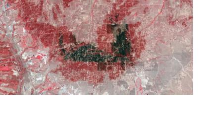
In the picture, the darkest gray and black areas represent the most severely burned while the unburned forest patches are bright red. The pink colour indicated unburned grasslands. Buildings, roads, and other developed areas are light gray or white.

