• English
  • Español
  • Français

United
Nations


Office for Outer Space Affairs
UN-SPIDER Knowledge Portal

  • Home
  • About Us
    • What is UN-SPIDER?
    • About UNOOSA
    • Publications
    • Jobs
    • Meet the Team
    • Contact
  • Space Application
    • Satellite Technology
    • Emergency Mechanisms
    • Recovery Mechanisms
    • International Asteroid Warning Network
    • Space Mission Planning Advisory Group
    • International Space Weather Initiative
    • Space Technologies in the UN
    • User Stories
  • Links & Resources
    • Data Applications
      • Disaster Recovery
    • Data Sources
    • GIS and Remote Sensing Software
    • Online Learning Resources
    • Institutions
  • Risks & Disasters
    • Disaster Risk Management
    • Early Warning Systems
    • Emergency and Disaster Management
    • Natural Hazards
    • Sendai Framework
    • The UN and Disaster Risk Management
    • The UN and Early Warning
    • The UN and Disaster Management
  • Advisory Support
    • Advisory Missions
    • Emergency Support
    • Virtual Advisory Support
    • Recommended Practices
    • Training Activities
    • Practical Uses
  • Network
    • Regional Support Offices
    • GP-STAR
    • MHEWS
    • IWG-SEM
  • Projects
    • SPEAR
    • SEWS-D
    • EvIDENz
    • Flood GUIDE
  • News & Events
    • News
    • Events Calendar
    • UN-SPIDER Events Archive
  • Admin
    • SAM Items

Breadcrumb

  • Home
  • News and Events
  • View Active News
  • United States: Half of The Country Experiencing Drought
  • United States: Half of the country experiencing drought

United States: Half of the country experiencing drought

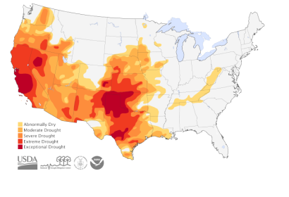
Scientists from the US created this map of dought areasDrought in the US

In early May 2014, the United States National Drought Center, in cooperation with the United States Department of Agriculture, the National Oceanic and Atmospheric Administration (NOAA), and the University of Nebraska-Lincoln developed a map, which shows the extended area affected by high temperatures and subsequent droughts in the United States.

The map is based on satellite and on the ground information regarding climate, sea and water conditions all around the country. The results are based on NASA measurements and models of drought monitoring and show that nearly 15 per cent of the country was suffering of extreme to exceptional drought in the beginning of May.

This is not news for the Plains and Southwest regions, where scientists see a pattern developing. The drought has the highest impact in California, especially on fruit and vegetable agriculture. More than half of the country's wheat crops are also affected by some level of drought.
Earth Observatory
Mon, 19 May 2014 - 09:27

Footer menu

  • Contact
  • Terms of Use

User account menu

  • Log in