• English
  • Español
  • Français

United
Nations


Office for Outer Space Affairs
UN-SPIDER Knowledge Portal

  • Home
  • About Us
    • What is UN-SPIDER?
    • About UNOOSA
    • Publications
    • Jobs
    • Meet the Team
    • Contact
  • Space Application
    • Satellite Technology
    • Emergency Mechanisms
    • Recovery Mechanisms
    • International Asteroid Warning Network
    • Space Mission Planning Advisory Group
    • International Space Weather Initiative
    • Space Technologies in the UN
    • User Stories
  • Links & Resources
    • Data Applications
      • Disaster Recovery
    • Data Sources
    • GIS and Remote Sensing Software
    • Online Learning Resources
    • Institutions
  • Risks & Disasters
    • Disaster Risk Management
    • Early Warning Systems
    • Emergency and Disaster Management
    • Natural Hazards
    • Sendai Framework
    • The UN and Disaster Risk Management
    • The UN and Early Warning
    • The UN and Disaster Management
  • Advisory Support
    • Advisory Missions
    • Emergency Support
    • Virtual Advisory Support
    • Recommended Practices
    • Training Activities
    • Practical Uses
  • Network
    • Regional Support Offices
    • GP-STAR
    • MHEWS
    • IWG-SEM
  • Projects
    • SPEAR
    • SEWS-D
    • EvIDENz
    • Flood GUIDE
  • News & Events
    • News
    • Events Calendar
    • UN-SPIDER Events Archive

Breadcrumb

  • Home
  • News and Events
  • View Active News
  • Using GPS Data To Characterize Earthquake Fault Lines
  • Using GPS data to characterize earthquake fault lines

Using GPS data to characterize earthquake fault lines

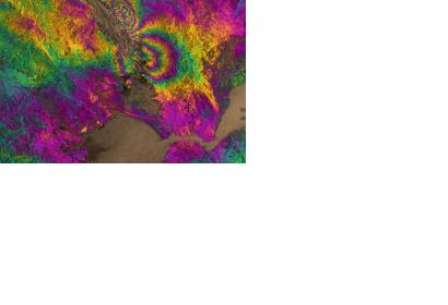
Satellite radar image of the magnitude 6.0 South Napa earthquake (Image: ESA)Satellite radar image of the magnitude 6.0 South Napa earthquake (Image: ESA)

The University of Iowa, in cooperation with the United States Geological Survey (USGS), published a study on how GPS and satellite data can be used in real-time to describe a fault line of an earthquake within one day. Using this new method, aid can be delivered faster and more precisely than ever before.

An earthquake, which took place on August 24, 2014 in South Napa, California, was analyzed for the study by Earth and Environmental Sciences assistant professor William Barnhart. A three-dimensional map of how the earthquake with a magnitude of 6.0 moved the ground surface was created, by using only GPS and satellite measurements.

"By having the 3D knowledge of the earthquake itself, we can make predictions of the ground shaking, without instruments to record that ground shaking, and then can make estimates of what the human and infrastructure impacts will be - in terms of both fatalities and dollars," Barnhart said.

Especially for the developing world, this new approach is of great interest, since it does not require expensive traditional rapid response instruments but only satellite and GPS data. "On an international scale, it dramatically reduces the time between when an earthquake happens, when buildings start to fall down, and when aid starts to show up," Barnhart added.
The University of Iowa
Wed, 25 Mar 2015 - 09:33

Footer menu

  • Contact
  • Terms of Use

User account menu

  • Log in