The CommonSpace Initiative - Digital Twins for Commonwealth Nations Project aims to enhance disaster risk management and resilience in select Commonwealth nations using cutting-edge satellite data and digital twin technology. Jointly implemented by the United Nations Office for Outer Space Affairs (UNOOSA) and SpaceData Inc., with technical support from the University of Bonn’s ZFL and Maxar Technologies, the initiative demonstrates the power of geospatial innovation in supporting sustainable development and climate adaptation efforts.
Background Information
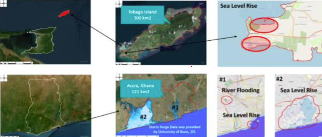
The project follows the Declaration of Intent on the CommonSpace Initiative made by UNOOSA and acknowledged by the Commonwealth Secretariat in late 2024. In alignment with the Space2030 Agenda and the EW4All (Early warnings for all (EW4All) | UNDRR) Initiative launched at COP27, the project focused on creating AI-driven digital twins for disaster-prone areas in Trinidad and Tobago and Ghana between January and March 2025. These digital twins simulate flooding and sea level rise, offering practical insights for emergency preparedness and response.
Check out the Press Release for the Joint Declaration here
Methods
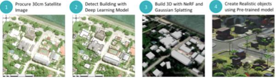
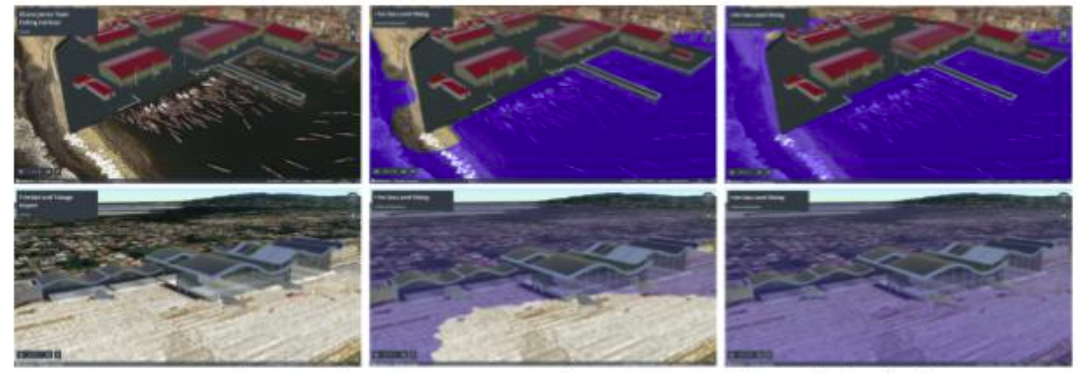
For Trinidad and Tobago (Tobago Island) and Ghana (Accra), very high-resolution (30–50 cm) optical satellite imagery was procured through Maxar Technologies. AI models were then used by SpaceData Inc. to generate LOD1 (Level of Detail 1) 3D models for large-scale analysis and LOD3 models for select high-priority areas such as ports and informal settlements.
Using deep learning and 3D reconstruction techniques such as NeRF and Gaussian Splatting, realistic urban models were produced. Blender and Cesium Ion platforms were utilized to simulate dynamic scenarios like flash floods and storm surges.
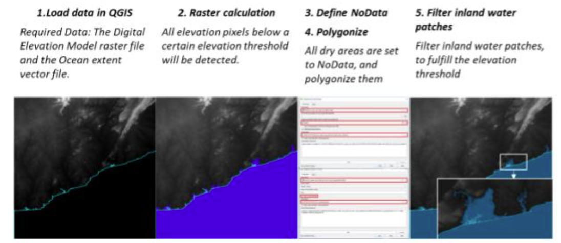
In parallel, storm surge simulations were conducted with technical guidance and model outputs from the University of Bonn, based on the UN-SPIDER Recommended Practices: Use of Digital Elevation Data for Storm Surge Coastal Flood Modelling
Result
In Ghana and Trinidad and Tobago, the project delivered:
- Very high-resolution optical satellite images (30–50 cm)
- Digital twin datasets in GIS-ready formats for LOD (Level of Detail) 1
- Simulation videos visualizing potential flooding and sea level rise impacts
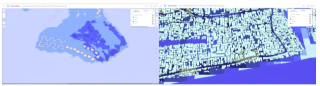
- Interactive 3D scenes hosted on Cesium Ion and ArcGIS Online platforms
Simulation and Promotion videos:
· Check out Space & AI Saving Lives | A Digital Twin - Accra, Ghana
· Flooding video in Trinidad and Tobago
Using Cesium ion platform, 3D data format is converted to 3D Tile format in which the data is smoothly operated through the platform. Cesium ion is a secure, cloud-based platform for streaming optimized 3D geospatial data. It offers global content like terrain, imagery, and buildings, which can be combined with your own data and shared via web apps.
In ArcGIS Online Scene Viewer, it can visualize and analyze scenes that present geographic information in an intuitive and interactive 3D environment.
· ArcGIS Online Scene Viewer in this project: https://www.arcgis.com/home/webscene/viewer.html?webscene=990ff45d1fca47199d18acba800f9da6
Impact
The Commonwealth Digital Twin Project enhanced disaster preparedness in Trinidad and Tobago and Ghana by producing AI-driven digital twin models from high-resolution satellite imagery. These models enabled realistic flood and sea-level rise simulations, supporting risk assessment and early warning planning. The project also strengthened local technical capacity through the use of advanced tools like Cesium Ion and ArcGIS Pro, and demonstrated scalable use cases for other Commonwealth nations. It
fostered multi-stakeholder collaboration and contributed to the UN-SPIDER disaster risk management cycle, aligning with global initiatives such as EW4All and the Space2030 Agenda.
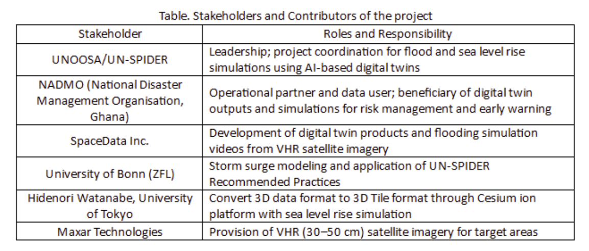
Stakeholders
This project emphasises collaboration with multi stakeholders, including UN agencies, national governments, space agencies, academia, and private space companies. The role of each stakeholder is as shown below.
Applications and Next Steps
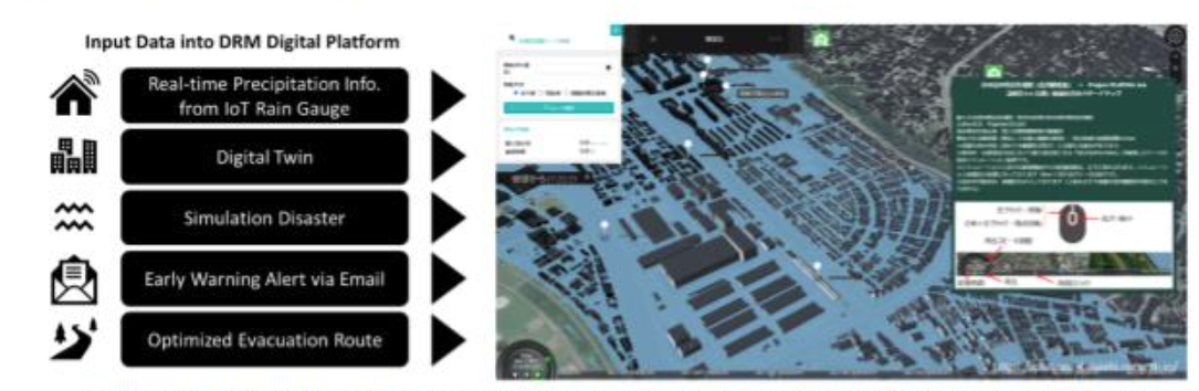
The project’s simulations support disaster preparedness, emergency planning, and infrastructure investment decisions. They have a potential of visualizing evacuation scenarios, identifying vulnerable structures, and improving early warning response systems. UNOOSA and partners are exploring ways to integrate IoT sensors (e.g., rain gauges and water level sensors) and create a 3D digital platform for optimized evacuation route planning.
Future steps include expanding the project to other Commonwealth nations, guided by country requests and regional needs assessments. Workshops and knowledge-sharing platforms are also planned to enhance local technical capacities and foster intergovernmental collaboration.
The Commonwealth Digital Twin Project exemplifies how space-based innovation and digital transformation can drive resilience in the face of escalating climate disasters, aligning with global agendas such as the Sendai Framework, SDG 13, and the UN Space2030 Agenda.