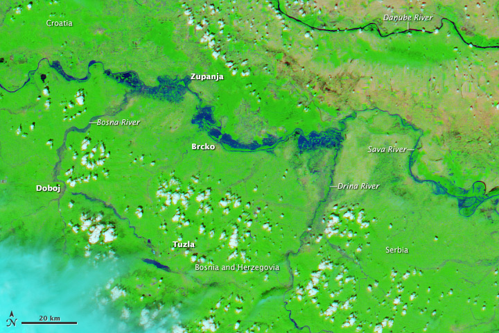
In mid-May 2014, Serbia, Bosnia and Herzegovina and Croatia experienced the worst flood in over 120 years. The extreme floods had been caused by heavy rainfall during three days, from 14 to 16 May 2014. In Bosnia, one third of the country was flooded affecting over one million people. According to BBC, officials stated that more than a quarter of the population has no access to clean water. In Serbia, tens of thousands of people had to be evacuated from their homes. Losses are being estimated to amount to a billion Euros.
Various international mechanisms and other agencies have provided satellite-based information and maps to support the flood responders:
- International Charter: Space and Major Disasters: The mechanism was activated on 21 May by the Russian Space Agency ROSCOSMOS and UN-SPIDER's Regional Support Office in Russia, EMERCOM for the floods in Serbia. Maps will be published on the Charter's website once they are available.
- Copernicus Emergency Mapping Service: The European service produced various delineation and reference maps for Croatia, Bosnia & Herzegovina and Serbia. The service furthermore provides an aggregator of Emergency Mapping GeoRSS feeds.
- ESA: Sentinel-1 satellite adds images to the Balkan Flood relief efforts. The satellite is not yet operation, but it has provided radar data that was used by the Copernicus emergency Management Service to create maps of the flooded area.
- MapAction: Volunteers from the non-profit crowdsource mapping group MapAction were deployed to Belgrade in response to the severe flooding in Serbia and the Balkans. The volunteers produced several maps for example on the number of people in evacuation centres in Belgrade and on flood-affected areas in Serbia.
- NASA Earth Observation: NASA published one satellite image captured by the Moderate Resolution Imaging Spectroradiometer (MODIS) on NASA’s Aqua satellite on 19 May 2014 of Croatia, Serbia, and Bosnia and Herzegovina
- DLR/ZKI: The German Aerospace Centre Center for Satellite-based Crisis Information published a classification result of DLR/ZKI's fully automatic TerraSAR-X flood processor capturing the flooded region along Drina and Sava Rivers.
- HOT OSM: The crowdsource mapping organisation Humanitarian OpenStreetMap Team has compiled further resources including a map of flooded zones as of 20 May 2014 based on data from NASA Lance Modis and the European Commission Copernicus programme.
- Esri: The company created a collection with before and after imagery of the flooding in Southeast Europe. Images, in false color (water appears in blue-green color), were captured by the RapidEye 1 satellite.
If you are aware of any additional sources of satellite imagery or maps, feel free to contact us at un-spider [at] unoosa.org
