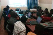
Virtual training course for Directorate of Civil Protection of Niger
This virtual training course was organized by UN-SPIDER at the request of the National Directorate of Civil Protection of Niger. The course targeted staff working in the Directorate, staff from other government agencies engaged in the recently established Operational Centre for Alert Watch and Crisis Management (COVACC), and students enrolled in the Civil Protection Academy. The course is meant to allow staff in the Directorate to benefit from the use of this UN-SPIDER Recommended Practice to map the geographic extent of floods in Niger. The virtual training course was organized in collaboration with the United Nations Country Office in Niger. The course was offered in French language to achieve the proposed aim.
-
UN-SPIDER Virtual training course on flood mapping using Sentinel 1 imagery and Google Earth Engine.
Ms. Alice Bourdet of the UN-SPIDER programme.
The target group included:
Staff working in the Directorate.
Staff from other government agencies engaged in the recently established COVACC.
Students enrolled in the Civil Protection Academy.
The training course covered the following topics:
Introduction to the principles of Synthethic Aperture Radar (SAR) imagery processing.
Mapping the geographic extent of floods using Google Earth Engine.
Elaboration of maps of flooded areas using Quantum GIS software.