Uzbekistan

country taxonomy block

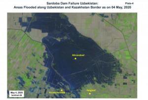
Using space-based information, the Centre for Space Science and Technology Education in Asia and the Pacific (CSSTEAP) affiliated to the United Nations has analysed the recent failure of a dam around the Sardoba Reservoir in Uzbekistan. Following a week of heavy rain in the region, the wall of the dam broke on 1 May and flooded surroundings in Uzbekistan as well as Kazakhstan to the north. According to media reports, the breach led to the evacuation of thousands of people in the area. 

The analysis carried out by CSSTEAP makes use of MODIS multi-temporal satellite images to identify the maximum spread of the floods, which was observed on 2 May. Waters receded in the following days, although they are still visibile along the border between the two countries on imagery from 12 May.

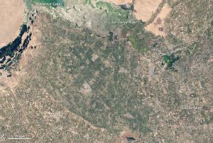
With the help of Landsat 8 and…

more
Publishing date 19/05/2020

The Japan International cooperation Agency (JICA) has provided the Institute of Geology and Geophysics in Uzbekistan with computer and GIS technology to monitor natural processes that may cause disasters such as earthquakes and landslides.

The GIS and remote sensing technology will enhance the observation activities of the Institute. Researchers have already been trained to work with the new technology. They will be able to recognize changes and developments and use them for forecasting and mitigation of disasters. The Institute will also receive software for satellite images processing. Nurtaev Bakhtiar, the Deputy Director of the Geology Institute added: “All this will allow us to analyse the systematic risks and improve methods for estimating seismic and landslide hazards.” 

more
Publishing date 07/03/2014
Geographic Information Science and Technologies have evolved into a key instrument for managing our societies, environments and infrastructures, as well as individuals’ daily lives.
 
Continued success of this development depends on cooperation across disciplines, open information policies and a highly educated workforce.
 
more