![]()
United
Nations
Forest Fire
, processed by ESA, CC BY-SA 3.0 IGO.")
Definition
Facts and figures
Further information
UN-SPIDER Regional Support Offices with hazard-specific expertise
Related content on the Knowledge Portal

When analysing wildfires and their impacts, remote sensing instruments provide frequent, broad coverage at minimal incremental cost and at no risk, compared with traditional in situ monitoring. Over the past 20 years, the research community has developed tools and techniques to capture key aspects of fire behavior and impacts, with data from spaceborne instruments such as the Multiangle Imaging Spectroradiometer (MISR).
The NASA Disasters Program, in cooperation with the Active Aerosol Plume-height (AAP) project, has developed the first-ever interactive 3D map of MISR fire plume-height data, which demonstrates the height of smoke plumes emanating from the Australian fires. The 3D data was captured by NASA’s Terra satellite which flew over the eastern coast of Australia on 16 December 2019. The map shows that in…
read more03/02/2020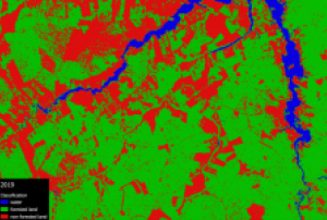 This Recommended Practice aims to (1) conduct a supervised land cover classification in QGIS using the SCP plugin and (2) to conduct change detection analysis. These skills are applicable to a vast range of disasters throughout the entire disaster management cycle. In this example, the remote sensing technique is applied to monitor deforestation in a part of the Amazon rainforest south of Santarém, Pará, in Brazil. However, it can be applied to any other study area. The required inputs are two or more satellite images of the same area at a different point in time. This will result in an…
The training date is in the past. However, videos and resources of the training can be accessed here.
This webinar will focus on a NASA instrument that was launched and installed on the International Space Station in summer 2018. Designed to study terrestrial ecosystems and plant water stress from the ISS, ECOSTRESS can also be used to better understand crop health, volcanoes, urban heat, wildland fires, coastal systems, and much more.
The primary science and applications mission of ECOSTRESS is to address three critical questions around vegetation health and agriculture:
- How is the terrestrial biosphere responding to changes in water availability?
- How do…

Major disasters such as droughts and wildfires are driven by the dryness of vegetation. To enhance the monitoring of plant water stress, NASA launched and installed a new sensor on the International Space Station. ECOSTRESS (ECOsystem Spaceborne Thermal Radiometer Experiment on Space Station) allows identifying loss of water in leaves- even before they show visible signs of trouble.
The image to the left shows a product derived from ECOSTRESS data, indicating that the forest fires during the 2019 Amazon dry season were concentrated in water-stressed areas, which are not visible on optical imagery. “To the naked eye, the fires appear randomly distributed throughout the forest,…
read more14/11/2019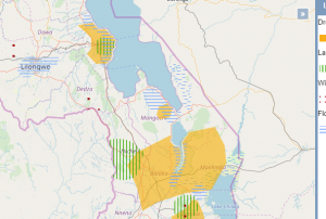 GIS Malawi is a webmapper which provides various vector and raster layers covering a broad range of topics including natural hazards.Publishing institution:
 The Global Ecosystem Dynamics Investigation (GEDI) produces high resolution laser ranging observations of the 3D structure of the Earth. GEDI’s precise measurements of forest canopy height, canopy vertical structure, and surface elevation greatly advance our ability to characterize important carbon and water cycling processes, biodiversity, and habitat. GEDI’s data on surface structure are valuable for weather forecasting, forest management, glacier and snowpack monitoring, and the generation of more accurate digital elevation models.Publishing institution:
Satellite technology became an integral part of efforts to detect and contain forest fires in Mecklenburg Western Pomerania, Germany at the end of June and early July. The German Aerospace Center (DLR) used satellite information, along with images captured by the Modular Aerial Camera System (MACS), to create maps, which provided emergency services with up-to-date information about areas affected by the fires.
When tracking the fires near Lübtheen, for example, the DLR Center for Satellite-Based Crisis Information (ZKI) used a freely available Sentinel-2 image, in which false-colour data offered valuable information about the status of the fires. Additionally, ZKI made use of data acquired by the Visible Infrared Imaging Radiometer Suite (VIIRS) and the Moderate Resolution Imaging Spectroradiometer (MODIS) to determine the locations of the fires.…
read more25/07/2019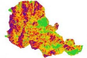 Los incendios forestales pueden resultar en la pérdida de vidas humanas. También tienen la capacidad de influir en diferentes procesos ecológicos, ya que son responsables de eliminar parcial o completamente la capa de vegetación (Petropoulos et al., 2014) Por lo tanto, es esencial evaluar la gravedad del área impactada. Por esta razón, esta práctica se desarrolló para ayudar a contribuir en la evaluación de áreas afectadas por incendios forestales. El análisis de estas áreas puede llevarse a cabo utilizando diferentes métodos a saber, en el suelo y utilizando herramientas de teledetección. La…
In the past year, “there were 315 natural disaster events recorded with 11,804 deaths, over 68 million people affected, and US$131.7 billion in economic losses around the world.” This is according to the Centre for Research on the Epidemiology of Disasters (CRED) in its recently released 2018 Natural Disasters Report.
While these 2018 natural disaster values represent a decrease when compared with the annual averages from 2008 to 2017, some geographic areas still experienced great losses of life and damages due to natural hazards. Indonesia was most adversely impacted in terms of lives claimed, with earthquakes in August and September 2018 that left a total of 4,904 people dead or missing, according to the CRED. Earthquakes also accounted for the greatest number of deaths among natural disasters worldwide in 2018. And among all types of natural hazards, floods affected the greatest number of people during the…
read more01/07/2019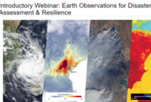
The training date is in the past. However, videos and resources of the training can be accessed here.
According to a UN report, between 1998 and 2017, the U.S. alone lost $944.8 billion USD from disasters. Between 1978 and 2017, losses from extreme weather events rose by 251 percent. It is critical to develop disaster management strategies to reduce and mitigate disaster risks. A major factor in regional risk assessment is evaluating the vulnerability of lives and property to disasters. Environmental information about disasters, their spatial impact, and their temporal evolution can play an important role as well.
This webinar series will focus on Earth observation (EO) data useful for disaster risk assessment. The series will cover disasters including tropical cyclones, flooding, wildfires, and heat stress…
read more
Term Parents
UN-SPIDER Regional Support Offices with hazard-specific expertise
![]()