![]()
United
Nations
Tsunami
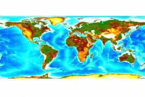
 and the Ohio State University (OSU) used satellite altimeters to observe “merging tsunamis”. The image comes from a data-based computer model that shows Tohoku-oki tsunami waves propagation. Waves peaks are depicted in red-brown, while depressions in sea surface appear in blue-green. Grayscale outlines show the location of mid-ocean ridges, peaks, and islands. Image: NASA.")
Definition
Facts and figures
Further information
UN-SPIDER Regional Support Offices with hazard-specific expertise
Related content on the Knowledge Portal
 of 2.7 m (i.e., less than one floor) and the share of built-up area could be estimated with a MAE of 13.3 %, when compared to a reference data set.") Publishing institution:
Publishing institution: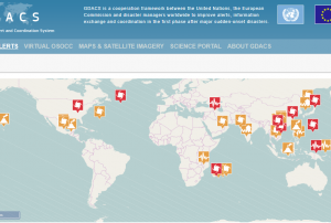 Derived products from various satellites processed by agencies in the field of disaster mapping.Publishing institution:
-
Derived products from various satellites processed by agencies in the field of disaster mapping.Publishing institution:
-
Derived products from various satellites processed by agencies in the field of disaster mapping.Publishing institution:
 After the TAM was conducted in Myanmar, innovative impacts were completed following a recommendation. “Emergency Operation Centre (EOC)”, which is comprised of four units including “Remote Sensing Unit” and “Risk Assessment and Emergency Response Unit” was established in the Ministry of Social Welfare, Relief & Resettlement (MSWRR). The capacity building of MSWRR and other related institutes in remote sensing and GIS were strengthened. The Disaster Management Training Centre now conducts courses in remote sensing/GIS. Myanmar has also become the first country in ASEAN to apply for universal access to the International Charter. Myanmar government is aware of the National Spatial Data Infrastructure (NSDI) and one map policy that has been initiated by the Ministry of Education is very crucial.read morePublishing institution:
 ,
, 
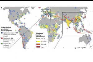
In order to encourage the targeted retrieval of space-based information and data by disaster risk reduction practitioners, content on the Portal is systematically enriched with metadata. For instance, data sources are marked up with data about their file type, satellite/sensor and spatial coverage and whether they relate to the disaster risk management or emergency response phase. The tool features a range of filters that draw on the metadata, thereby allowing users to narrow down their search, for example, filtering available GIS software by hazard type. This ensures that users efficiently find the content that is most relevant to them. At the same time, the Portal encourages the discovery of resources related to those accessed by the user, by providing links to them on the same page. This allows for contextualisation and highlights links between resources…
read morePublishing institution: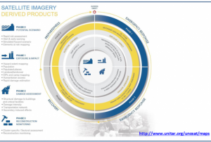 ,
, 
Based on optical and radar images of different resolutions, UNOSAT products are also enriched with the available baseline GIS datasets and crowdsourcing data. Satellite-derived analysis performed by UNOSAT is delivered in the form of GIS Data, Static Maps, Live Web Maps, and Reports, and is then shared with a wide range of end-users such as UN Agencies, International Organizations, and Governments.
Publishing institution: ,
, 
In the aftermath of catastrophic natural disasters, such as earthquakes and tsunamis, our society has experienced significant difficulties in assessing disaster impact in the limited amount of time. In recent years, the quality of satellite sensors and access to and use of satellite imagery and services has greatly improved. More and more space agencies have embraced data-sharing policies that facilitate access to archived and up-to-date imagery. We developed to estimate building damage uses high-resolution synthetic aperture radar (TerraSAR-X) data from the 2011 Tohoku earthquake and tsunami. The damage function we developed involves the relationship between changes in the sigma nought values of pre- and post event TerraSAR-X data and the damage ratio of washed- away from buildings.
Publishing institution: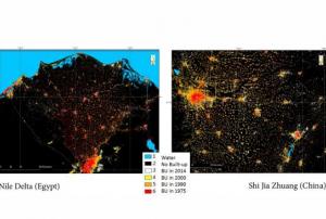 ,
, 
The Global Human Settlement (GHS) framework produces global open source spatial information about the human presence on the planet over time. This is in the form of built up maps, population density maps and settlement maps. This information is generated with evidence-based analytics and knowledge using new spatial data mining technologies. The framework uses heterogeneous data including global archives of fine-scale satellite imagery, census data, and volunteered geographic information. The data is processed fully automatically and generates analytics and knowledge reporting objectively and systematically about the presence of population and built-up infrastructures.
read more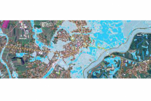 ,
, 
The guidelines will be reviewed and updated periodically, in order to integrate new best practices and to be responsive to evolutions in technology and end-user needs. The IWG-SEM chair has the responsibility to initiate the review, by agreement of the Working Group.
The production and the maintenance of the guidelines are based on a joint effort by the members of the International Working Group on Satellite-based Emergency Mapping (IWG- SEM), a voluntary group of organizations involved in satellite-based emergency mapping. It was founded to improve cooperation, communication and professional standards among the global network of satellite-based emergency mapping providers. The chairperson of the group is nominated for a term of one year and is responsible for organizing the monthly telecons and bi-annual meetings. The current chair is from the Department of Geoinformatics, Z_GIS University of Salzburg / Spatial Services Ltd, Austria…
read morePublishing institution:
Term Parents
UN-SPIDER Regional Support Offices with hazard-specific expertise
![]()