  • English
  • Español
  • Français

United
Nations


Office for Outer Space Affairs
UN-SPIDER Knowledge Portal

  • Home
  • About Us
    • What is UN-SPIDER?
    • About UNOOSA
    • Publications
    • Jobs
    • Meet the Team
    • Contact
  • Space Application
    • Satellite Technology
    • Emergency Mechanisms
    • Recovery Mechanisms
    • International Asteroid Warning Network
    • Space Mission Planning Advisory Group
    • International Space Weather Initiative
    • Space Technologies in the UN
    • User Stories
  • Links & Resources
    • Data Applications
      • Disaster Recovery
    • Data Sources
    • GIS and Remote Sensing Software
    • Online Learning Resources
    • Institutions
  • Risks & Disasters
    • Disaster Risk Management
    • Early Warning Systems
    • Emergency and Disaster Management
    • Natural Hazards
    • Sendai Framework
    • The UN and Disaster Risk Management
    • The UN and Early Warning
    • The UN and Disaster Management
  • Advisory Support
    • Advisory Missions
    • Emergency Support
    • Virtual Advisory Support
    • Recommended Practices
    • Training Activities
    • Practical Uses
  • Network
    • Regional Support Offices
    • GP-STAR
    • MHEWS
    • IWG-SEM
  • Projects
    • SPEAR
    • SEWS-D
    • EvIDENz
    • Flood GUIDE
  • News & Events
    • News
    • Events Calendar
    • UN-SPIDER Events Archive

Breadcrumb

  • Home
  • WorldView-1
  • WorldView-1

WorldView-1

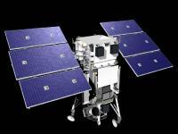
The WorldView-1 offers a high-capacity, panchromatic imaging system which features 0.46m resolution imagery.

Operating at an altitude of 496 kilometers, WorldView-1 satellite has an average revisit time of 1.7 days and is capable of collecting up to 750,000 square kilometers (290,000 square miles) per day of half-meter imagery. The satellite is also equipped with state-of-the-art geo-location capabilities and exhibits stunning agility with rapid targeting and efficient in-track stereo collection.

WorldView-1 satellite sensor was successfully launched from Vandenberg Air Force Base, California, U.S.A., at 11:35 Hrs Pacific Daylight Time (PDT) on September 18th, 2007.

Instrument: WV60 (WorldView-60 camera)
- spectral range 0.45 - 0.90 µm
- swath width: 17.6km at nadir
- pushbroom imager

18 Sep 2007
7years
Sun synchronous
95 minutes
Digital Globe
Map creation, change detection and in-depth image analysis
Drought
Glacial Lake Outburst
Landslide
Earthquake
Flood
Forest Fire
Mass Movement
Tsunami
Volcanic Eruption
No
Information about WorldView-1 on DigitalGlobe web page

Footer menu

  • Contact
  • Terms of Use

User account menu

  • Log in