The Risk and Recovery Mapping service is part of the Copernicus Emergency Management Service (CEMS). It is offered in the international context of the Sendai Framework for Disaster Risk Reduction and targets information layers that support decision-making in phases of the disaster management cycle that are not directly related to immediate response. The Risk and Recovery Mapping service offers products that can support a wide range of activities in the context of recovery, disaster risk reduction and preparedness, such as assessing recovery needs, mapping the long-term impact of the disaster event, and monitoring progress in reconstruction efforts. The service is funded by the European Commission and implemented through a variety of framework contracts.
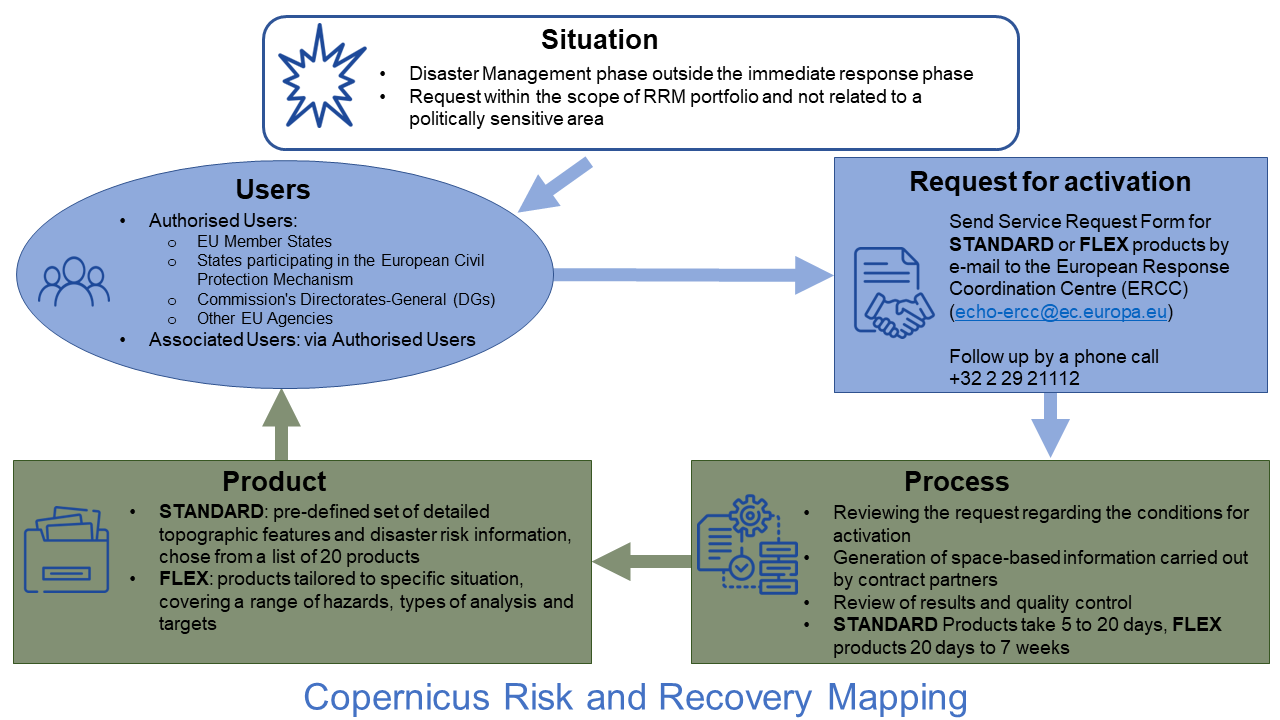
Types of Users
The service can be triggered by or through Authorized Users. Authorized Users are European Member States and other countries participating in the European Civil Protection Mechanism as well as the Commission's Directorates-General (DGs) and other EU Agencies. Associated Users may also benefit from the service but are required to go through Authorized Users to request the provision of any form of service. Associated Users include local, regional and other public entities, international governmental organizations, national and international non-governmental organizations, EU delegations, and others.
Conditions for Activation
The Risk and Recovery Mapping service is designed to support with risk and recovery efforts in the context of the European Union´s Civil Protection Mechanism and the Sendai Framework for Disaster Risk Reduction.
Criteria for the activation of the service are a pre-disaster risk, emergency situations or humanitarian crises related to disasters triggered by natural, technical, or anthropogenic hazards. The request should also fall within the technical capacity of the service and not exceed its capacity to cope with multiple simultaneous activations. The request is rejected if the security interests of the Union, its Member States or international partners would be harmed because of the likely use of service information for tactical or operational activities.
User Request/Point of Contact
Authorized Users may activate the service by sending a Service Request Form (SRF) by e-mail to the European Response Coordination Centre (ERCC) of the European Commission. Associated Users have to contact their respective Focal Points who are authorized to trigger the service.
In regard of the variety of recovery efforts, two different product types are offered: Risk and Recovery mapping STANDARD and Risk and Recovery Mapping FLEX.
STANDARD products allow to choose from a pre-defined set of detailed topographic features and disaster risk information. Users may choose one or more items from a list of 20 products depending on their needs, included topics are floods, forest fires, humanitarian crisis, soil erosion and landslide risk, ground deformation, damage assessment and reconstruction monitoring, impact assessment and exposure after disasters, reference data and map layouts for printing.
FLEX products allow to tailor the products specific to the given situation, by filling in the free text in the Service Request Form. FLEX products are relevant at city and regional level and cover a range of natural and man-made hazards, different types of analysis, and targets, such as population, infrastructure, agriculture, environment and economic assets. The products can also support processes such as cost-benefit analysis of major investment projects for disaster prevention and climate change adaptation and help effective investments under the European Structural and Investment Funds.
The respective service request form for STANDARD or FLEX products must be sent by e-mail to the European Response Coordination Centre (ERCC) (echo-ercc [at] ec.europa.eu). Every request must be followed by a phone call to ERCC (+32-2-29-21112).
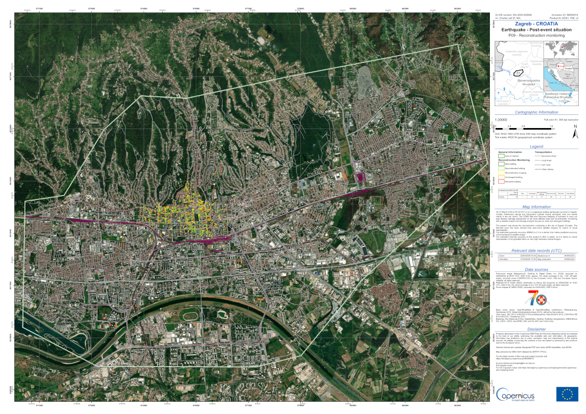
On 22 March 2020 at 05: 24 UTC on a 5.4 magnitude shallow earthquake occurred in Zagreb, Croatia. Preliminary reports and information indicate heavily damaged roofs and assets mainly in the city centre. The CEMS Risk and Recovery Mapping is activated to carry out post disaster damage assessment in the most affected area and reconstruction monitoring with a detailed impact and damage analysis focused on roofs and damaged buildings.
The presented map shows the earthquake damage grade assessment in the city of Zagreb (Croatia). The thematic layer has been derived from post-event satellite imagery and drone images for the historical city centre by means of visual interpretation. The estimated geometric accuracy (RMSE) is 2.5 m or better, from native positional accuracy of the background satellite image, and 3.4 m or better for the drone images. The estimated thematic accuracy of this product is 85% or better, as it is based on visual interpretation of recognizable items on very high resolution optical imagery.
Available at: https://emergency.copernicus.eu/mapping/ems-product-component/EMSN074_01ZAGREB_P09RCMON_00OVERVIEW/2
Process
Once the service request is properly submitted, it undergoes a review regarding the scope of Copernicus Mapping, technical feasibility, sensibility, and capacity (see conditions for activation). In case the request is rejected, the Authorized User is informed.
Products are available to the requesting Authorized User free of charge. The generation of space-based information is carried out by framework contract partners. STANDARD products take 5 to 20 days to be delivered, FLEX products are usually set to 20 calendar days, but may take up to 7 weeks, depending on the request.
Products
The Authorized User will receive satellite-derived, digital data, that can be downloaded and integrated in the user’s GIS environment, as well as overview/detail maps. Each activation delivery is accompanied by a report that includes a description of the methodology, input data used and a description of each product. Depending on the product choice the products are standardized or depend on the set of parameters which the user has chosen when placing the service request.