Iraq

country taxonomy block

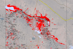
The Iraqi government on Tuesday 7 May 2013 declared a state of maximum alert in all its service agencies to deal with the floods that have affected several cities in southern Iraq since Sunday.

After UN-SPIDER received a request from Iraq to facilitate the acquisition of satellite imagery to assess the extent of the flood and the damages caused, UN-SPIDER activated its network. The Indian Space Agency acquired imagery and UN-SPIDER provided its servers to disseminate the data. The images are processed by UNOSAT by rapid mapping for flood extension. The maps will be made available to Iraq free of charge.

UNOSAT has published the processed product on their website: http://www.unitar.org/unosat/node/44/1744 including the following statement: "This map illustrates satellite-detected areas of flood waters in the Wasit Governorate in eastern Iraq as detected by Resourcesat-2 imagery collected on 7...

more
Publishing date 13/05/2013

Iraq is planning the launch of a satellite at the end of the year to better manage water crises, as the newspaper Almonitor reported. The launch is part of a scientific project to monitor desertification and water shortages in the country.

Deputy Minister of Communications Amir al-Bayati said, “Members of the high commission for the satellite project, which consists of seven ministries, have discussed the launching mechanism of the project and its economic feasibility, in addition to a well-defined cooperation process between all concerned parties in order to avoid any roadblocks that might stand in the way of completing the project.”

Rafed al-Jabouri, the general coordinator of the project, said, “Iraq will accomplish this project in cooperation with the Italian La Sapienza University and an Iraqi team of 15 researchers from three ministries, who underwent space training.”

There is a pressing need for this resource, as Almonitor points...

more
Publishing date 08/05/2013


A terrible dust storm raged through Iraq in the first week of July 2009. According to news reports, many Iraqis considered the storm to be the worst in living memory. Hundreds of people reported to the hospital for respiratory distress, and the blowing dust interfered with air and land travel for nearly a week.
This natural-color (photo-like) image from the Moderate Resolution Imaging Spectroradiometer (MODIS) on NASA’s Aqua satellite shows the area at the height of the storm, on July 5. In places the dust is only a veil, and the landscape below is recognizable. Parts of the Tigris and Euphrates Rivers are visible. In other places, however, the dust is a thick blanket, completely blocking the ground from view. The city of Baghdad is hidden. An animation of images from July 1...
more
Publishing date 13/07/2009

Contact Person
Essa Al-fayadh

Mobile: +964 7901 845870
Email: essaalfayadh [at] yahoo.com (essaalfayadh[at]yahoo[dot]com)