Based on observations and recommendations of several technical advisory missions organised under the framework of UN-SPIDER in several countries in Asia, this international capacity building programme was conducted with a view of sharing latest developments in using space-based information for flood risk mapping and modelling.
Flood risk mapping, modelling and assessment using space technology
Experts from UN-SPIDER, the Centre for Space Science and Technology Education in Asia and the Pacific (CSSTEAP), the International Water Management Institute (IWMI), the Economic and Social Commission for Asia and the Pacific (ESCAP), the Indian Institute of Remote Sensing (IIRS), the Indian Space Research Organisation (ISRO), the Geo-Informatics and Space Technology Development Agency (GISTDA) of Thailand and the National Disaster Reduction Centre of China (NDRCC).
A total of 19 participants from 11 countries from Asia and the Pacific region attended the training programme, including officials from nine Asian countries (Bhutan, Cambodia, China, India, Indonesia, Myanmar, Nepal, Philippines and Sri Lanka) and one Pacific country (Fiji).
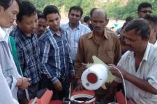
The programme included theory lectures and experience sharing by the experts. The theory lectures covered climate change and disaster risk reduction, adaptation to enhanced floods, concepts of flood inundation mapping, operational flood alert system of ISRO, monitoring and damage assessment using Space technology, global flood detection system and flood inundation modelling using HEC tools. Hands-on sessions were offered by IWMI and IIRS on the flood inundation mapping using multi-resolution satellite data and flood inundation modelling. The participants also visited the downstream area of the recent floods in Northern India (Kedarnath) that caused heavy losses of life and damage to the property a month ago. The Central Water Commission (Government of India) demonstrated the Acoustic Doppler Current Profiler (ADCP) that collects data on flood levels and discharge of the river and transmits the data trough telemetry system to the servers for flood analysis and decision making.