• English
  • Español
  • Français

United
Nations


Office for Outer Space Affairs
UN-SPIDER Knowledge Portal

  • Inicio
  • Sobre nosotros
    • Sobre ONU-SPIDER
    • Acerca de UNOOSA
    • Publicaciones
    • Ofertas de trabajo
    • Conozca el Equipo
    • Contacto
  • Aplicación Espacial
    • Guías Tecnológicas
    • Mecanismos de Emergencia
    • Mecanismos de Recuperación
    • Red Internacional de Alerta de Asteroides
    • Grupo Asesor para la Planificación de Misiones Espaciales
    • Iniciativa Internacional sobre Meteorología Espacial
    • Tecnologías Espaciales en la ONU
    • Historias de Usuarios
  • Enlaces y Recursos
    • Aplicación de datos del mes
      • Disaster Recovery
    • Fuentes de Datos
    • SIG y Software de Percepción Remota
    • Recursos de capacitación en línea
    • Instituciones
  • Riesgos y Desastres
    • Gestión del Riesgo de Desastres
    • Alerta temprana
    • Gestión de Desastres y Emergencias
    • Amenazas Naturales
    • El Proceso de la Reducción de Desastres Post-2015
    • La ONU y la Gestión del Riesgo de Desastres
    • La ONU y Alerta Temprana
    • La ONU y la Gestión de Desastres
  • Asesoría
    • Misiones de Asesoría
    • Apoyo en caso de Emergencia
    • Asesoría Virtual
    • Prácticas Recomendadas
    • Actividades de Entrenamiento
    • Usos Prácticos
  • Redes
    • Oficinas Regionales de Apoyo
    • GP-STAR
    • IN-MHEWS
    • IWG-SEM
  • Proyectos
    • SPEAR
    • FOSAT-S
    • EvIDENz
    • Flood GUIDE
  • Noticias y Eventos
    • Noticias
    • Eventos
    • Eventos pasados

Breadcrumb

  • Home
  • Satellite Observations Used To Measure How Much Fires Pollute The Atmosphere
  • Satellite observations used to measure how much fires pollute the atmosphere

Satellite observations used to measure how much fires pollute the atmosphere

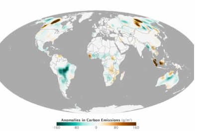
Difference from average emissions for 2014 in grams of carbon per square meter per year (Image: NASA)Difference from average emissions for 2014 in grams of carbon per square meter per year (Image: NASA)

The National Oceanic and Atmospheric Administration (NOAA) has published a report in which the quantity of carbon dioxide and other pollutants produced by fires that remains in the atmosphere has been determined.

The estimation of the polluting emissions into the atmosphere is possible thanks to the data produced by computer models that combine satellite observations of burned area and active fires together with information about vegetation, fuel loads, and other details. Only the Moderate Resolution Imaging Spectroradiometers (MODIS) on NASA’s Aqua and Terra satellites detect approximately 10,000 active fires on a normal day of August.

Some of the conclusions of the report are summarized in NASA’s website: “In 2014, fires released about 2,030 teragrams of carbon into the atmosphere. That’s just slightly below the 2001–2013 average of 2,034 teragrams per year. While global emissions were average in 2014, North America and the Indonesian archipelago saw a very active fire season. South America and northern Africa had an unusually quiet season.”
NASA
Wed, 19 Aug 2015 - 14:56
Global

Footer menu

  • Contact
  • Terms of Use

User account menu

  • Log in