• English
  • Español
  • Français

United
Nations


Office for Outer Space Affairs
UN-SPIDER Knowledge Portal

  • Inicio
  • Sobre nosotros
    • Sobre ONU-SPIDER
    • Acerca de UNOOSA
    • Publicaciones
    • Ofertas de trabajo
    • Conozca el Equipo
    • Contacto
  • Aplicación Espacial
    • Guías Tecnológicas
    • Mecanismos de Emergencia
    • Mecanismos de Recuperación
    • Red Internacional de Alerta de Asteroides
    • Grupo Asesor para la Planificación de Misiones Espaciales
    • Iniciativa Internacional sobre Meteorología Espacial
    • Tecnologías Espaciales en la ONU
    • Historias de Usuarios
  • Enlaces y Recursos
    • Aplicación de datos del mes
      • Disaster Recovery
    • Fuentes de Datos
    • SIG y Software de Percepción Remota
    • Recursos de capacitación en línea
    • Instituciones
  • Riesgos y Desastres
    • Gestión del Riesgo de Desastres
    • Alerta temprana
    • Gestión de Desastres y Emergencias
    • Amenazas Naturales
    • El Proceso de la Reducción de Desastres Post-2015
    • La ONU y la Gestión del Riesgo de Desastres
    • La ONU y Alerta Temprana
    • La ONU y la Gestión de Desastres
  • Asesoría
    • Misiones de Asesoría
    • Apoyo en caso de Emergencia
    • Asesoría Virtual
    • Prácticas Recomendadas
    • Actividades de Entrenamiento
    • Usos Prácticos
  • Redes
    • Oficinas Regionales de Apoyo
    • GP-STAR
    • IN-MHEWS
    • IWG-SEM
  • Proyectos
    • SPEAR
    • FOSAT-S
    • EvIDENz
    • Flood GUIDE
  • Noticias y Eventos
    • Noticias
    • Eventos
    • Eventos pasados

Breadcrumb

  • Home
  • Washington Wildfires Captured By NASA’s Aqua Satellite
  • Washington wildfires captured by NASA’s Aqua satellite

Washington wildfires captured by NASA’s Aqua satellite

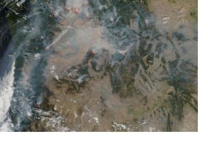
Satellite image of active wildfires across Western U.S., outlined in red (Image: NASA)Satellite image of active wildfires across Western U.S., outlined in red (Image: NASA)

NASA’s Earth observation Aqua satellite spotted the wildfires burning throughout California, Oregon, Washington, Idaho and Montana states on August 23. One of the most important blazes was reported in the Okanogan Complex, in Washington State. It has burned 287,704 acres (116,000 hectares) and killed three firefighters. More than 1,774 fire personnel from 33 states are currently fighting it or working to support the firefighting effort.

The Aqua satellite was launched in 2002 and is part of the NASA-centered international Earth Observing System (EOS). It is a scientific research artifact in orbit around the Earth that gathers information about precipitations, the Earth’s water cycle, soil moisture, ice cover, storms and wildfires.

It features a Moderate Resolution Imaging Spectroradiometer (MODIS), capable of detecting actively burning areas, which are coloured red on the photo, thanks to its thermal bands.


Space.com
Fri, 28 Aug 2015 - 10:30
United States of America

Footer menu

  • Contact
  • Terms of Use

User account menu

  • Log in