• English
  • Español
  • Français

United
Nations


Office for Outer Space Affairs
UN-SPIDER Knowledge Portal

  • Inicio
  • Sobre nosotros
    • Sobre ONU-SPIDER
    • Acerca de UNOOSA
    • Publicaciones
    • Ofertas de trabajo
    • Conozca el Equipo
    • Contacto
  • Aplicación Espacial
    • Guías Tecnológicas
    • Mecanismos de Emergencia
    • Mecanismos de Recuperación
    • Red Internacional de Alerta de Asteroides
    • Grupo Asesor para la Planificación de Misiones Espaciales
    • Iniciativa Internacional sobre Meteorología Espacial
    • Tecnologías Espaciales en la ONU
    • Historias de Usuarios
  • Enlaces y Recursos
    • Aplicación de datos del mes
      • Disaster Recovery
    • Fuentes de Datos
    • SIG y Software de Percepción Remota
    • Recursos de capacitación en línea
    • Instituciones
  • Riesgos y Desastres
    • Gestión del Riesgo de Desastres
    • Alerta temprana
    • Gestión de Desastres y Emergencias
    • Amenazas Naturales
    • El Proceso de la Reducción de Desastres Post-2015
    • La ONU y la Gestión del Riesgo de Desastres
    • La ONU y Alerta Temprana
    • La ONU y la Gestión de Desastres
  • Asesoría
    • Misiones de Asesoría
    • Apoyo en caso de Emergencia
    • Asesoría Virtual
    • Prácticas Recomendadas
    • Actividades de Entrenamiento
    • Usos Prácticos
  • Redes
    • Oficinas Regionales de Apoyo
    • GP-STAR
    • IN-MHEWS
    • IWG-SEM
  • Proyectos
    • SPEAR
    • FOSAT-S
    • EvIDENz
    • Flood GUIDE
  • Noticias y Eventos
    • Noticias
    • Eventos
    • Eventos pasados

Breadcrumb

  • Home
  • International Charter And Copernicus Emergency Management Service Activated For Earthquake In Afghanistan
  • International Charter and Copernicus Emergency Management Service activated for earthquake in Afghanistan

International Charter and Copernicus Emergency Management Service activated for earthquake in Afghanistan

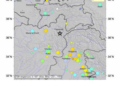
Hindu Kush Region of Afghanistan struck by 7.5 earthquake on 26 October (Image: USGS).Hindu Kush Region of Afghanistan struck by 7.5 earthquake on 26 October (Image: USGS).

The International Charter: Space and Major Disasters has been triggered to provide satellite-based emergency maps in response to the 7.5 magnitude strong earthquake that struck the Hindu Kush region of north eastern Afghanistan at 09:09 UTC on 26 October. Additionally the Copernicus Emergency Management Service was activated on 26 October 18:48 UTC, requesting reference and grading maps. 

The International Charter was activated on 26 October 2015, at 18:24:00 (UTC+01:00) by UNITAR-UNOSAT on behalf of UN OCHA. The latest numbers count 80 reported casualties in Afghanistan, another hundred people were injured. The Hindu Kush region is located in the Badakshan Province, close to the Pakistan border. Due to mountains and remote settlements assessing the situation is complicated. Further severed communications and landside impede the access of rescue teams towards the affected Afghan regions.   

The International Charter noted: “The United States Geological Survey (USGS) reports that while the earthquake was on the higher end of the Richter scale (classed as a major earthquake) it occurred at a depth of approximately 210 km which means that it was in effect a relatively shallow earthquake. Because of this, the earthquake caused less damage than seismic activity of this magnitude normally would.”

Still, the earthquake caused severe harm in Afghanistan and Pakistan, in Pakistan estimates reported over 200 casualties. Besides Afghanistan and Pakistan the earthquake was also felt in regions of India and China. 

Read more: EMSR145: Earthquake in Afghanistan, USGS, ReliefWeb, GDACS Event Report 
Earthquake in Afghanistan
Wed, 28 Oct 2015 - 11:42
Afghanistan

Footer menu

  • Contact
  • Terms of Use

User account menu

  • Log in