• English
  • Español
  • Français

United
Nations


Office for Outer Space Affairs
UN-SPIDER Knowledge Portal

  • Inicio
  • Sobre nosotros
    • Sobre ONU-SPIDER
    • Acerca de UNOOSA
    • Publicaciones
    • Ofertas de trabajo
    • Conozca el Equipo
    • Contacto
  • Aplicación Espacial
    • Guías Tecnológicas
    • Mecanismos de Emergencia
    • Mecanismos de Recuperación
    • Red Internacional de Alerta de Asteroides
    • Grupo Asesor para la Planificación de Misiones Espaciales
    • Iniciativa Internacional sobre Meteorología Espacial
    • Tecnologías Espaciales en la ONU
    • Historias de Usuarios
  • Enlaces y Recursos
    • Aplicación de datos del mes
      • Disaster Recovery
    • Fuentes de Datos
    • SIG y Software de Percepción Remota
    • Recursos de capacitación en línea
    • Instituciones
  • Riesgos y Desastres
    • Gestión del Riesgo de Desastres
    • Alerta temprana
    • Gestión de Desastres y Emergencias
    • Amenazas Naturales
    • El Proceso de la Reducción de Desastres Post-2015
    • La ONU y la Gestión del Riesgo de Desastres
    • La ONU y Alerta Temprana
    • La ONU y la Gestión de Desastres
  • Asesoría
    • Misiones de Asesoría
    • Apoyo en caso de Emergencia
    • Asesoría Virtual
    • Prácticas Recomendadas
    • Actividades de Entrenamiento
    • Usos Prácticos
  • Redes
    • Oficinas Regionales de Apoyo
    • GP-STAR
    • IN-MHEWS
    • IWG-SEM
  • Proyectos
    • SPEAR
    • FOSAT-S
    • EvIDENz
    • Flood GUIDE
  • Noticias y Eventos
    • Noticias
    • Eventos
    • Eventos pasados

Breadcrumb

  • Home
  • NASA’s Microsatellites To Improve Hurricane Prediction
  • NASA’s microsatellites to improve hurricane prediction

NASA’s microsatellites to improve hurricane prediction

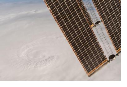
Monitoring Hurricane Matthew. Image: NASAMonitoring Hurricane Matthew. Image: NASA

Satellites improvements are an important contribution to the monitoring and forecasting of future storms. NASA is managing a new group of eight economical microsatellite observatories, called the Cyclone Global Navigation Satellite System (CYGNSS) that will be orbiting the Earth at low level. Each observatory will be evenly placed around the world. The mission’s launch is expected for 12 December 2016 from Cape Canaveral in Florida and it will start operating at the beginning of the 2017 hurricane season in the Atlantic. 

The goal is to measure areas within a storm that were out of reach to space observation in the past like strong inner rain-bands and superficial winds close to the eyewall of hurricanes. The measurement will be done with GPS signals and technology on a small scale, which means that there is no need for active devices like radars or lasers.  This technology is essential for emergency management authorities and other stakeholders like weather forecasters that are in charge of protecting the health and welfare of communities in coastal areas.  

Up to now, remote sensors were unable to see through intense rain in the inner core of a hurricane or to observe the rapid changes occurring.  By placing satellites in different points of the world and by using GPS signal scattering, this new remote sensing technique will make observations below the heavy rain curtain. 


CYGNSS Satellite Mission Aims to Improve Hurricane Forecasting
Thu, 3 Nov 2016 - 06:23
Global

Footer menu

  • Contact
  • Terms of Use

User account menu

  • Log in